35 Berrydale Road, Liverpool, L14 7AH
About 35 Berrydale Road
35 Berrydale Road is a two-bedroom mid-terrace house in Liverpool (L14 7AH). It has a recorded floor area of 64 m² (around 689 sq ft) and construction records dating it to 2012 onwards. The latest certificate (December 2024) shows a C (score 78), near the top of the C band. Earlier certificates rated it B (March 2014); the latest reading is one band lower. Between certificates, window efficiency dropped from Very Good to Good. The recommended improvements would lift it to A (score 92), a 2-band jump. The home occupies a corner plot.
At 64 m² it's 15.8% smaller than the typical home in the postcode (76 m² median across 23 EPCs). It lags the bulk of the postcode on energy efficiency (less efficient than 74% of similar EPCs). On the market in March 2014 and unlisted since — roughly 12 years. Today's modelled estimate of £191,000 is 41.5% above the 2014 sale price.
What this property has
Inside
- Bedrooms2
- Bathrooms2
Outside
- Corner plotYes
Building
- RefurbishedYes
Everything you need to know about 35 Berrydale Road
The true value, the hidden risks and the full sale history, in one report.
Pick your report · every report is £14.99
One time fee only - money back guarantee

The data behind every report


Energy performance
35 Berrydale Road's carbon output is low for the local stock.
EPC Rating
Get a survey for this property
Level 2 HomeBuyer Report
We've checked 10 risk factors against the available data for this property and believe a Level 2 HomeBuyer Report could be a suitable option for you.
From £495 · Includes VAT
Planning history
35 Berrydale Road has no planning applications on record.
A planning report still maps activity across the surrounding area and reads this property's extension & conversion potential.
Sales history & valuation
£191,000
Modelled from EPC, postcode comparables.
£134,995
Recorded with HM Land Registry.
Sales timeline
12 March 2014Most recent
£134,995
Median price across the last 5 sales in L14 7AH: £235,000 (2025–2022).
Nearby sales in L14 7AH
Versus other Berrydale Road homes
Price per m² for 35 Berrydale Road lags the street by a wide margin.
Price per m²
£2,109
Street avg £2,388
Floor Area
64 m²
Street avg 76 m²
Habitable Rooms
3 rooms
Street avg 4 rooms
CO₂ Emissions
1.5 t/year
Street avg 1.4 t/year
Everything you need to know about 35 Berrydale Road
The true value, the hidden risks and the full sale history, in one report.
Pick your report · every report is £14.99
One time fee only - money back guarantee
The data behind every report
Similar properties nearby
1 Swanside Avenue
L14 7NP
1 Eton House, Marwood Road
L14 7AY
1 Pilch Lane
L14 7QA
1 Coronation Drive, Knotty Ash
L14 7NT
1 Coronation Avenue, Knotty Ash
L14 7NS
1 Lodge Court, Berrydale Road
L14 7AL
1 Holly Bank Avenue
L14 7AG
1 Gordon Drive, Dovecot
L14 7PU
The neighbourhood at a glance
Rail-style transport is unusually close for this postcode.
Crime
6/mo
Rising year-on-year across the wider district.
Nearest stop
0.2 km
Ashfield Way — bus stop.
Closest school
0.3 km
Malvern Primary School. 49 schools nearby.
Go deeper on the local area
A Local Area report breaks down crime, transport links, schools and air quality in depth.
Road noise across the postcode
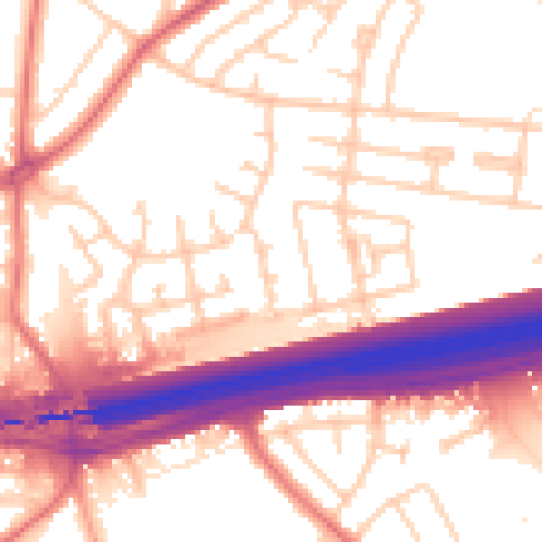
Daytime· 07:00 – 23:00
55.6dB

Night-time· 23:00 – 07:00
46.6dB