8 Elm Gardens, Halifax, HX3 0AB
About 8 Elm Gardens
8 Elm Gardens is a three-bedroom semi-detached house in Halifax (HX3 0AB). It has a recorded floor area of 95 m² (around 1023 sq ft), construction records dating it to 1930-1949 and council tax band D. The latest certificate (April 2025) shows a D (score 60), on the cusp of jumping into the C band. The recommended improvements would push it to C (score 79). Other recorded features include a conservatory and outbuildings.
Most recent transfer was August 2025 at £270,000 — fresh data. Across 2000–2025, sale prices on this property compounded at 4.2% per year. On a £-per-square-foot basis, the last sale (£264/sq ft) was about 75.4% above the typical sold price in the postcode. At 95 m² it's 15.2% smaller than the typical home in the postcode (112 m² median across 5 EPCs).
What this property has
Inside
- Bedrooms3
- Bathrooms1
- CloakroomYes
- ConservatoryYes
Outside
- Private gardenYes
- GarageDetached
- OutbuildingsYes
Everything you need to know about 8 Elm Gardens
The true value, the hidden risks and the full sale history, in one report.
Pick your report · every report is £14.99
One time fee only - money back guarantee

The data behind every report


Energy performance
EPC Rating
Get a survey for this property
Level 3 Building Survey
Because the property has permanent outbuildings, we believe a Level 3 building survey should be considered.
From £885 · Includes VAT
Planning history
8 Elm Gardens has no planning applications on record.
But the area is active
1 notable application nearby — larger schemes and conversions that could reshape the street. The report maps them all.
Sales history & valuation
Latest sale on 8 Elm Gardens was the highest on Land Registry record across the postcode.
£285,000
Modelled from EPC, postcode comparables and a sale-price growth of 4.2% per year over 25 years.
£270,000
Growth on file: 4.2% per year over 25 years.
Sales timeline
28 August 2025Most recent
£270,000
+184.2%over 25 years10 March 2000
£95,000
Median price across the last 5 sales in HX3 0AB: £212,500 (2021–2009).
Versus other Elm Gardens homes
8 Elm Gardens outperforms the street on price per m² by a wide margin.
Price per m²
£2,842
Street avg £2,075
Floor Area
95 m²
Street avg 105 m²
Habitable Rooms
6 rooms
Street avg 5 rooms
CO₂ Emissions
5.3 t/year
Street avg 5.7 t/year
Everything you need to know about 8 Elm Gardens
The true value, the hidden risks and the full sale history, in one report.
Pick your report · every report is £14.99
One time fee only - money back guarantee
The data behind every report
Similar properties nearby
1 Copley Wood View, New Lane, Skircoat Green
HX3 0TE
1 Copley Drive
HX3 0US
1 Copley View
HX3 0TX
1 Copley Grove
HX3 0TZ
1 Delph View, Wakefield Gate
HX3 0NQ
1 Cheltenham Place
HX3 0AW
1 Delph Brow, Skircoat Moor Road
HX3 0GZ
1 Bristol Street
HX3 0PT
The neighbourhood at a glance
Reported crime in the wider district is trending notably upward year-on-year.
Crime
3/mo
Rising year-on-year across the wider district.
Nearest stop
0.1 km
Free School Lane Hazelwood Court — bus stop.
Closest school
0.6 km
Holy Trinity Primary School, A Church of England Academy. 26 schools nearby.
Go deeper on the local area
A Local Area report breaks down crime, transport links, schools and air quality in depth.
Road noise across the postcode
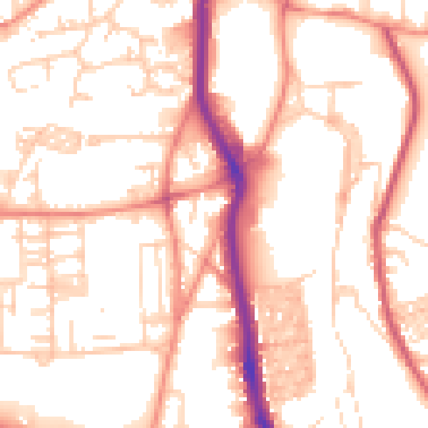
Daytime· 07:00 – 23:00
54.0dB

Night-time· 23:00 – 07:00
43.6dB