2 St Giles Close, Gilesgate, Durham, DH1 1XH
About 2 St Giles Close
2 St Giles Close is a three-bedroom property in Gilesgate, Durham, Durham (DH1 1XH). It has council tax band E.
Untraded for 19 years, with the last transfer in May 2007. That sale landed at the peak of the pre-credit-crunch market, which is a useful reference point when interpreting the price. Across 1999–2007, sale prices on this property compounded at 11.1% per year.
What this property has
Inside
- Bedrooms3
- Dining roomYes
Outside
- Private gardenRear
- GarageYes
Building
- Heating systemGas
- RefurbishedYes
Everything you need to know about 2 St Giles Close
The true value, the hidden risks and the full sale history, in one report.
Pick your report · every report is £14.99
One time fee only - money back guarantee

The data behind every report


Energy performance
No EPC on record
This property doesn't have an Energy Performance Certificate yet. An EPC is required to sell or let — and unlocks our automated valuation.
Get a survey for this property
Level 2 HomeBuyer Report
We've checked 10 risk factors against the available data for this property and believe a Level 2 HomeBuyer Report could be a suitable option for you.
Planning history
2 St Giles Close has no planning applications on record.
But the area is active
72 notable applications nearby — larger schemes and conversions that could reshape the street. The report maps them all.
Sales history & valuation
2 St Giles Close has more than doubled in price since the earliest registered sale in 1999.
£249,000
Growth on file: 11.1% per year over 7 years.
Sales timeline
3 May 2007Most recent
£249,000
+116.6%over 7 years21 December 1999
£114,950
Median price across the last 5 sales in DH1 1XH: £155,000 (2025–2024).
Nearby sales in DH1 1XH
38 St Giles Close, Gilesgate, Durham, DH1 1XH
Sold Oct 2025
£150,00025 St Giles Close, Gilesgate, Durham, DH1 1XH
Sold Sept 2025
£175,00016 St Giles Close, Gilesgate, Durham, DH1 1XH
Sold Jun 2025
£157,50039 St Giles Close, Gilesgate, Durham, DH1 1XH
Sold Oct 2024
£155,00028 St Giles Close, Gilesgate, Durham, DH1 1XH
Sold Mar 2024
£155,000
Everything you need to know about 2 St Giles Close
The true value, the hidden risks and the full sale history, in one report.
Pick your report · every report is £14.99
One time fee only - money back guarantee
The data behind every report
Similar properties nearby
The neighbourhood at a glance
Daytime road noise here sits well below conversation level — a quiet pocket of the postcode.
Crime
6/mo
Steady year-on-year across the wider district.
Nearest stop
0.1 km
Magdalene Street — bus stop.
Closest school
0.5 km
Laurel Avenue Community Primary School. 21 schools nearby.
Go deeper on the local area
A Local Area report breaks down crime, transport links, schools and air quality in depth.
Road noise across the postcode
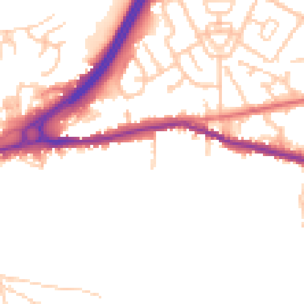
Daytime· 07:00 – 23:00
49.2dB

Night-time· 23:00 – 07:00
41.0dB