10 Springfield, Kegworth, Derby, DE74 2DP
About 10 Springfield
10 Springfield is a five-bedroom detached house in Kegworth, Derby, Derby (DE74 2DP). It has a recorded floor area of 186 m² (around 2002 sq ft), construction records dating it to 1967-1975 and council tax band D. The latest certificate (June 2018) shows a D (score 65), on the cusp of jumping into the C band. The recommended improvements would push it to C (score 78). Records show the property has been extended at some point in its history. The home occupies a corner plot.
At 186 m² the property is well over the postcode median (131 m² across 8 EPCs), placing it in the larger end of the local stock. One planning record on file: tree works approved in 2007. Past consents include tree works, meaningful when judging how the property has evolved. Today's modelled estimate of £449,000 is 34% above the 2018 sale price. Last sale on file: £335,000 in September 2018.
What this property has
Inside
- Bedrooms5
- Bathrooms3
- Utility roomYes
- EnsuiteYes
Outside
- Private gardenRear
- GarageIntegral
- Corner plotYes
Building
- Previously extendedYes
Everything you need to know about 10 Springfield
The true value, the hidden risks and the full sale history, in one report.
Pick your report · from £14.99
One time fee only - money back guarantee

The data behind every report







Energy performance
10 Springfield's carbon output runs well above what efficient homes in the postcode produce.
EPC Rating
Certificate validity
Valid until 7 June 2028

Get a survey for this property
Level 3 Building Survey
Because the property has been extended more than once, we believe a Level 3 building survey should be considered.
From £1,020 · Includes VAT
Planning history
1 application on record at 10 Springfield, Kegworth, Derby, DE74 2DP
- May 2007Tree WorksTreesOutcome in report
Pruning and lopping of overhanging branches to 14 no. Lime trees protected by Tree Preservation Order T/377
- Reference
- 07/00479/TPO
Unlock 10 Springfield, Kegworth, Derby, DE74 2DP's full planning history
You're seeing the shape of it. The report has the substance.
- Every decision — granted, refused or withdrawn (1 on record)
- All 1 application on this property in full, plus 39 notable nearby
- What the pattern means for extending or converting here
One time fee only - money back guarantee
Sales history & valuation
10 Springfield valuation sits well clear of the typical sold price in this postcode.
£449,000
Modelled from EPC, postcode comparables.
£335,000
Recorded with HM Land Registry.
Sales timeline
6 September 2018Most recent
£335,000
Median price across the last 5 sales in DE74 2DP: £310,000 (2020–2016).
Nearby sales in DE74 2DP
3 Springfield, Kegworth, Derby, DE74 2DP
Sold Dec 2020
£290,00011 Springfield, Kegworth, Derby, DE74 2DP
Sold May 2019
£335,0008 Springfield, Kegworth, Derby, DE74 2DP
Sold Oct 2018
£330,00022 Springfield, Kegworth, Derby, DE74 2DP
Sold Jan 2016
£310,00016 Springfield, Kegworth, Derby, DE74 2DP
Sold Apr 2013
£225,000
Versus other Springfield homes
Floor Area for 10 Springfield runs comfortably ahead of the street norm.
Price per m²
£1,801
Street avg £2,234
Floor Area
186 m²
Street avg 131 m²
Habitable Rooms
8 rooms
Street avg 7 rooms
CO₂ Emissions
7.1 t/year
Street avg 5.3 t/year
Everything you need to know about 10 Springfield
The true value, the hidden risks and the full sale history, in one report.
Pick your report · from £14.99
One time fee only - money back guarantee
The data behind every report
Similar properties nearby
1 Borough Street, Castle Donington
DE74 2LA
1 Bentley Road, Castle Donington
DE74 2UL
1 Ayrton Drive, Castle Donington
DE74 2BE
1 Balmoral Court, Hemington
DE74 2PX
1 Broadhill Road, Kegworth
DE74 2DQ
1 Avocet Close, Diseworth
DE74 2BG
1 Brooklet Farm, Isley Walton, Castle Donington
DE74 2RL
1 Apiary Gate, Castle Donington
DE74 2JA
The neighbourhood at a glance
Crime
89/mo
Falling year-on-year across the wider district.
Nearest stop
0.2 km
Suthers Road — bus stop.
Closest school
0.5 km
Kegworth Primary School. 2 schools nearby.
Go deeper on the local area
A Local Area report breaks down crime, transport links, schools and air quality in depth.
Road noise across the postcode
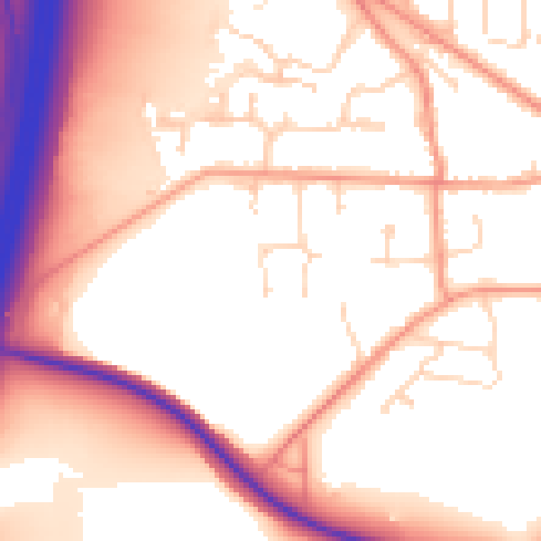
Daytime· 07:00 – 23:00
55.6dB

Night-time· 23:00 – 07:00
46.6dB