Are you a property professional?Get qualified leads from motivated homeowners.
Get started7 Hatherley Road, Sidcup, DA14 4BH
4 sales on record
About 7 Hatherley Road
A plain-English summary derived from public records, EPC certificates, sold prices and local data.
7 Hatherley Road is a semi-detached house in Sidcup (DA14 4BH). It has a recorded floor area of 68 m² (around 732 sq ft) and council tax band C. At 68 m² this is the 18th smallest of 33 units on EPC record in the building, where floor areas span 36–253 m². The building's EPC ratings span E to B across 33 units on file. The latest certificate (October 2018) shows a C (score 71).
At 68 m² the property is well over the postcode median (52 m² across 32 EPCs), placing it in the larger end of the local stock. A recent sale: £350,000 in September 2025. Across the public record there are 4 sales, relatively high churn for a single property. Across 2018–2025, sale prices here grew 0% per year, broadly in step with England's 0.2% HPI growth. On a £-per-square-foot basis, the last sale (£478/sq ft) was about 34.6% above the typical sold price in the postcode. 3 planning records sit against the property, 3 approved, 0 refused.
Energy performance
Every EPC certificate filed against this property — current rating, recorded improvements, and where there's headroom to reach a higher band.
EPC Rating
A
B
C
C71
D
E
F
G
Main Heating
Gas
Main Fuel
Gas
Hot Water
Good
Windows
Very Good
CO2 Emissions
2.3 t/year
Occupancy
Rented
Planning history
Applications and permits filed against 7 Hatherley Road, Sidcup, DA14 4BH, sourced from the PlanIt planning register.
- Jun 2017ConditionsGranted
Details of conditions 3 (materials and finishes), 12 (demolition and construction methodology), 13 (surface water and foul drainage) and 14 (sustainable development) pursuant to planning permission 16/01969/FUL for the erection of a 3 storey block with a linked communal access area to the existing building, alterations to the existing building to provide 2 x 2 bed flats and 4 x 1 bed flats and provision of parking.
Sales history & valuation
Recorded transactions, our model's current estimate, and a quick read on what neighbouring properties have sold for.
7 Hatherley Road saw 4 transfers in just over a decade — high turnover for the postcode.
Current estimate
See how we calculated this£355,000
Modelled from EPC, postcode comparables.
Last sold (2025)
£350,000
Recorded with HM Land Registry.
Sales timeline
Launch offer · 33% off
Buying 7 Hatherley Road, Sidcup, DA14 4BH? Know what you're getting into
Everything a buyer needs to know about this property, compiled into one in-depth report so there are no surprises after you offer.
Spot red flags before you buy
An AI-written breakdown of everything that matters
Versus other Hatherley Road homes
Four headline reads against 30 similar flats on this street, drawn from the latest EPC and Land Registry data.
Years Held for 7 Hatherley Road lags the street by a wide margin.
Price per m²
£5,147
Street avg £5,133
Floor Area
68 m²
Street avg 62 m²
CO₂ Emissions
2.3 t/year
Street avg 2.5 t/year
Similar properties nearby
A handful of close matches in the same postcode area, ranked by likeness on bedrooms, type and floor area.
The neighbourhood at a glance
A condensed read of the local area. Each tile links through to the full breakdown on the Sidcup district page.
Rail-style transport is unusually close for this postcode.
Crime
4/mo
Steady year-on-year across the wider district.
Nearest stop
0.1 km
Sidcup High Street / Station Road — bus stop.
Road noise across the postcode
Modelled day and night-time noise levels around DA14 4BH from Defra's strategic mapping. The pin marks this postcode's centroid.
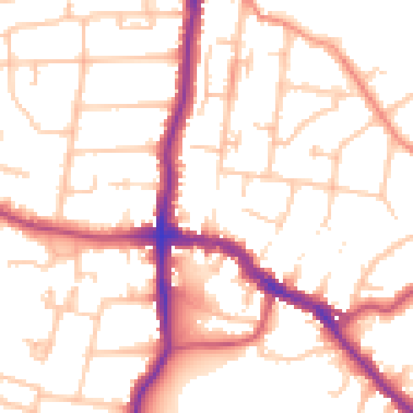
Daytime· 07:00 – 23:00
52.7dB
Everything within walking distance
Schools, transport stops and scenic spots near this property — 61 points of interest in total.
Common questions
The questions buyers, sellers and homeowners most often ask about 7 Hatherley Road, Sidcup, DA14 4BH. Each answer is also embedded as structured data for search engines.
