12 Mersea Road, Colchester, CO2 7EX
About 12 Mersea Road
12 Mersea Road is a one-bedroom mid-terrace house in Colchester (CO2 7EX). It has a recorded floor area of 35 m² (around 377 sq ft), construction records dating it to 1900-1929 and council tax band A. At 35 m² this is the 7th smallest of 16 units on EPC record in the building, where floor areas span 22–142 m². The building's EPC ratings span F to C, with this unit at the top. The latest certificate (November 2019) shows a C (score 69), just inside the C band. When first surveyed in November 2009 the rating was E, the property has climbed 2 bands since. Between certificates, window efficiency went from Poor to Average; while wall efficiency dropped from Poor to Very Poor.
It hasn't traded since February 2002, a hold of 24 years that's notably long for the area. Today's modelled estimate of £135,000 sits 94.2% above the 2002 sale of £69,500. On a £-per-square-foot basis, the last sale (£184/sq ft) was about 33% above the typical sold price in the postcode. At 35 m² it's 15.7% smaller than the typical home in the postcode (42 m² median across 15 EPCs). Its energy rating outperforms most of the postcode (better than 73% of similar EPCs).
What this property has
Inside
- Bedrooms1
Outside
- ParkingAllocated
Building
- Heating systemLpg
Everything you need to know about 12 Mersea Road
The true value, the hidden risks and the full sale history, in one report.
Pick your report · every report is £14.99
One time fee only - money back guarantee

The data behind every report


Energy performance
EPC Rating
Property Improvements
Changes detected from historical EPC data
Heating controls upgraded for better temperature management
Hot water efficiency improved
Windows upgraded, improving insulation
More low energy lighting installed
Heating controls changed
Hot water efficiency decreased
More low energy lighting installed
Heating controls upgraded for better temperature management
Low energy lighting percentage decreased
Get a survey for this property
Level 3 Building Survey
Because the property was built before 1919 and has solid (non-cavity) walls, we believe a Level 3 building survey should be considered.
From £820 · Includes VAT
Planning history
12 Mersea Road has no planning applications on record.
But the area is active
4 notable applications nearby — larger schemes and conversions that could reshape the street. The report maps them all.
Sales history & valuation
12 Mersea Road valuation sits well clear of the typical sold price in this postcode.
£135,000
Modelled from EPC, postcode comparables.
£69,500
Recorded with HM Land Registry.
Sales timeline
22 February 2002Most recent
£69,500
Median price across the last 5 sales in CO2 7EX: £88,000 (2020–2013).
Nearby sales in CO2 7EX
Versus other Mersea Road homes
On years held, 12 Mersea Road stands well clear of the street.
Price per m²
£1,986
Street avg £1,634
Floor Area
35 m²
Street avg 35 m²
Habitable Rooms
1 rooms
Street avg 2 rooms
CO₂ Emissions
1.7 t/year
Street avg 2.5 t/year
Everything you need to know about 12 Mersea Road
The true value, the hidden risks and the full sale history, in one report.
Pick your report · every report is £14.99
One time fee only - money back guarantee
The data behind every report
Similar properties nearby
1 Brigadier House, Captain Gardens
CO2 7LD
1 Bourne Court, Mersea Road
CO2 7RJ
1 Abbey Court, Meyrick Crescent
CO2 7QP
1 Bradman Court, Circular Road East
CO2 7GB
1 Caesar Court, Roman Circus Walk
CO2 7NG
1 Captain Gardens
CO2 7FX
1 Amies Court, Grimston Road
CO2 7RN
1 Battalion Walk
CO2 7GS
The neighbourhood at a glance
Rail-style transport is unusually close for this postcode.
Crime
5/mo
Rising year-on-year across the wider district.
Nearest stop
0.1 km
Town Railway Station — bus stop.
Closest school
0.4 km
St John's Green Primary School. 35 schools nearby.
Go deeper on the local area
A Local Area report breaks down crime, transport links, schools and air quality in depth.
Road noise across the postcode
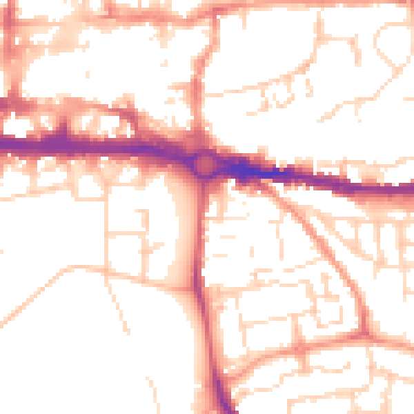
Daytime· 07:00 – 23:00
52.1dB

Night-time· 23:00 – 07:00
41.4dB