7a, Mount Pleasant Road, Wallasey, CH45 5EN
About 7a
7a is a detached house in Wallasey (CH45 5EN). It has a recorded floor area of 35 m² (around 377 sq ft), construction records dating it to 1967-1975 and council tax band A. At 35 m² this is the smallest unit on EPC record across the building (35–115 m²). The building's EPC ratings span D to B across 24 units on file. The latest certificate (February 2024) shows a C (score 69), just inside the C band.
At 35 m² it sits well below the postcode median (53 m² across 23 EPCs), making it one of the more compact homes locally.
Everything you need to know about 7a
The true value, the hidden risks and the full sale history, in one report.
30-day money-back guarantee

The data behind every report


Energy performance
EPC Rating
Get a survey for this property
Level 2 HomeBuyer Report
We've checked 10 risk factors against the available data for this property and believe a Level 2 HomeBuyer Report could be a suitable option for you.
From £495 · Includes VAT
Planning history
7a has no planning applications on record.
The full report still covers planning activity across the surrounding area.
Sales history & valuation
7a has no Land Registry sales on file, suggesting it has stayed in the same hands since registration began.
£116,000
Modelled from EPC, postcode comparables.
No sales recorded with HM Land Registry
That can mean the property has never traded since the registry began publishing in 1995, was a new build that hasn't been registered yet, or is held in the same hands long-term.
Median price across the last 5 sales in CH45 5EN: £116,000 (2025–2022).
Nearby sales in CH45 5EN
7f, Mount Pleasant Road, Wallasey, CH45 5EN
Sold Jul 2025
£142,50051 Mount Pleasant Road, Wallasey, CH45 5EN
Sold Dec 2024
£116,00041 Mount Pleasant Road, Wallasey, CH45 5EN
Sold Oct 2024
£255,000Flat 6, 3 Mount Pleasant Road, Wallasey, CH45 5EN
Sold Jun 2022
£99,00035 Mount Pleasant Road, Wallasey, CH45 5EN
Sold Nov 2021
£224,000
Versus other Mount Pleasant Road homes
Floor Area for 7a lags the street by a wide margin.
EPC Rating
69 (C)
Street avg 73 (C)
Floor Area
35 m²
Street avg 54 m²
CO₂ Emissions
1.6 t/year
Street avg 1.8 t/year
Habitable Rooms
2 rooms
Street avg 3 rooms
Everything you need to know about 7a
The true value, the hidden risks and the full sale history, in one report.
30-day money-back guarantee
The data behind every report
Similar properties nearby
The neighbourhood at a glance
Crime
5/mo
Steady year-on-year across the wider district.
Nearest stop
0.1 km
Rake Lane — bus stop.
Closest school
0.5 km
Mount Primary School. 17 schools nearby.
Go deeper on the local area
The full report breaks down crime, transport links, schools and air quality in depth.
Road noise across the postcode
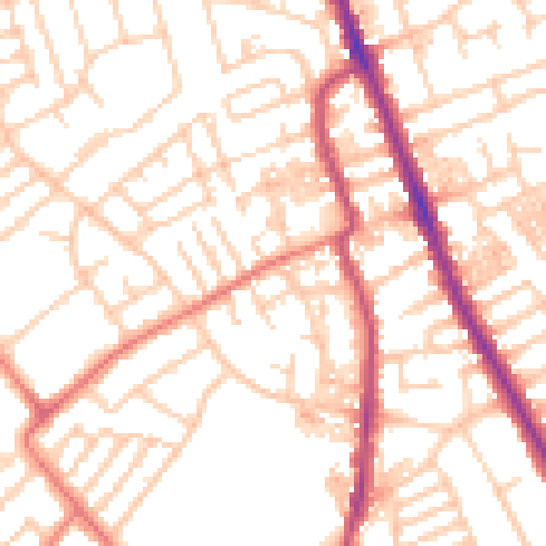
Daytime· 07:00 – 23:00
52.7dB

Night-time· 23:00 – 07:00
40.9dB