1c, Chalks Road, Bristol, BS5 9EN
About 1c
1c is an end-of-terrace house in Bristol (BS5 9EN). It has a recorded floor area of 48 m² (around 517 sq ft), construction records dating it to 2003-2006 and council tax band A. The latest certificate (May 2025) shows a C (score 75), near the top of the C band. The rating has held steady at C across 2 certificates since April 2015. Between certificates, roof efficiency went from Average to Good; while hot-water efficiency dropped from Very Good to Good. The recommended improvements would push it to B (score 91).
Today's modelled estimate of £236,000 is 21% above the 2021 sale price. On a £-per-square-foot basis, the last sale (£377/sq ft) was about 160% above the typical sold price in the postcode. Last sale on file: £195,000 in September 2021. That sale was during the post-pandemic price surge, when transactions cleared materially above pre-2020 trend.
Everything you need to know about 1c
The true value, the hidden risks and the full sale history, in one report.
30-day money-back guarantee

The data behind every report


Energy performance
1c's carbon output is low for the local stock.
EPC Rating
Property Improvements
Changes detected from historical EPC data
Hot water efficiency decreased
Loft insulation upgraded to recommended levels
Planning history
1c has no planning applications on record.
Notable planning nearby
23applications of note in the surrounding area
We flagged 1 thing worth checking at 1c
Independent checks surfaced things a buyer would want to understand before offering. The report explains each one in full, with the underlying data and what to ask.
- Signs of HMO activity in the area
30-day money-back guarantee
Sales history & valuation
The latest sale landed in the post-pandemic price surge — useful context when reading the figure.
£236,000
Modelled from EPC, postcode comparables.
£195,000
Recorded with HM Land Registry.
Sales timeline
29 September 2021Most recent
£195,000
Median price across the last 5 sales in BS5 9EN: £216,000 (2024–2020).
Versus other Chalks Road homes
1c outperforms the street on epc rating by a wide margin.
Price per m²
£4,063
Street avg £8,192
Floor Area
48 m²
Street avg 63 m²
Habitable Rooms
3 rooms
Street avg 4 rooms
CO₂ Emissions
1.5 t/year
Street avg 3.0 t/year
Everything you need to know about 1c
The true value, the hidden risks and the full sale history, in one report.
30-day money-back guarantee
The data behind every report
Similar properties nearby
The neighbourhood at a glance
Crime
11/mo
Steady year-on-year across the wider district.
Nearest stop
0.0 km
Blackswarth Road — bus stop.
Closest school
0.3 km
St Patrick's Catholic Primary School. 45 schools nearby.
Go deeper on the local area
The full report breaks down crime, transport links, schools and air quality in depth.
Road noise across the postcode
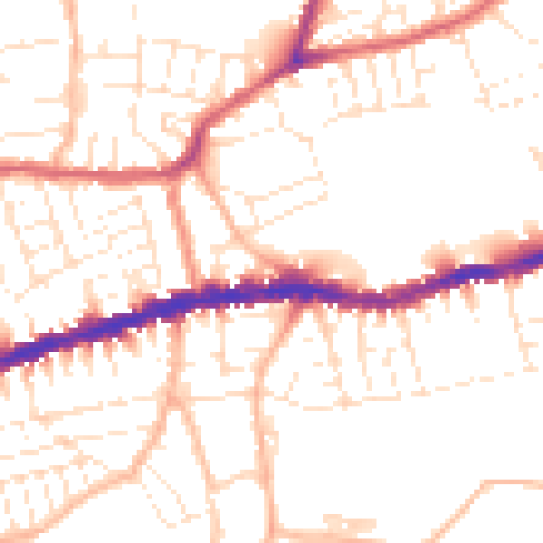
Daytime· 07:00 – 23:00
51.7dB

Night-time· 23:00 – 07:00
41.6dB