34 Nutfield Grove, Filton, Bristol, BS34 7LJ
4 sales on record
About 34 Nutfield Grove
A plain-English summary derived from public records, EPC certificates, sold prices and local data.
34 Nutfield Grove is a two-bedroom end-of-terrace house in Filton, Bristol, Bristol (BS34 7LJ). It has a recorded floor area of 47 m² (around 506 sq ft), construction records dating it to 1983-1990 and council tax band B. At 47 m² this is the 20th smallest of 83 units on EPC record in the building, where floor areas span 39–90 m². The building's EPC ratings span E to C, with this unit at the top. The latest certificate (April 2023) shows a C (score 74). When first surveyed in June 2010 the rating was D, the property has climbed 1 band since. Between certificates, roof efficiency went from Good to Very Good, window efficiency went from Average to Good and hot-water efficiency went from Average to Good.
Sale prices here have outpaced England HPI: 6.6% per year against 0% for the wider region. On a £-per-square-foot basis, the last sale (£553/sq ft) was about 125.9% above the typical sold price in the postcode. Last sale on file: £280,000 in September 2022. Across the public record there are 4 sales, relatively high churn for a single property. That sale was during the post-pandemic price surge, when transactions cleared materially above pre-2020 trend.
Before you offer
Know exactly what you're buying at 34 Nutfield Grove
Before you offer, see what the listing won't tell you, the true value, the red flags and the full history.
Already flagged here
Signs of HMO activity in the areaLarger development activity nearby
£9.99£14.99
Launch offer · save £5
What this property has
Pulled from EPC certificates, claim submissions and our property model. Empty categories are hidden — we only show what's known.
Inside
- Bedrooms2
- Bathrooms1
- Dining roomYes
Outside
- Private garden
Energy performance
Every EPC certificate filed against this property — current rating, recorded improvements, and where there's headroom to reach a higher band.
Current Certificate(1 of 5)
Apr 2023
EPC Rating
A
B
C
C74
D
E
F
G
Main Heating
—
Main Fuel
Gas
Hot Water
Good
Windows
Good
CO2 Emissions
1.6 t/year
Occupancy
Rented
Planning history
Applications and permits filed against 34 Nutfield Grove, Filton, Bristol, BS34 7LJ, sourced from the PlanIt planning register.
34 Nutfield Grove has no planning applications on record.
Notable planning nearby
130applications of note in the surrounding area
Before you offer
We flagged 2 things worth checking at 34 Nutfield Grove
Independent checks surfaced things a buyer would want to understand before offering. The report explains each one in full, with the underlying data and what to ask.
- Signs of HMO activity in the area
- Larger development activity nearby
Sales history & valuation
Recorded transactions, our model's current estimate, and a quick read on what neighbouring properties have sold for.
Price for 34 Nutfield Grove has grown more than fourfold since the 2000 starting point.
Current estimate
See how we calculated this£298,000
Modelled from EPC, postcode comparables and a sale-price growth of 6.6% per year over 22 years.
Last sold (2022)
£280,000
Growth on file: 6.6% per year over 22 years.
Sales timeline
Before you offerLaunch offer · save £5
Everything we know about 34 Nutfield Grove, in one report
What it's really worth, what could be wrong, and the planning, sales and area data in full.
What we flagged
- Signs of HMO activity in the area
- Larger development activity nearby
£9.99£14.99
Versus other Nutfield Grove homes
Four headline reads against 37 similar flats on this street, drawn from the latest EPC and Land Registry data.
On epc rating, 34 Nutfield Grove runs well behind the street norm.
EPC Rating
74 (C)
Street avg 76 (C)
Floor Area
47 m²
Street avg 48 m²
CO₂ Emissions
1.6 t/year
Street avg 1.5 t/year
Similar properties nearby
A handful of close matches in the same postcode area, ranked by likeness on bedrooms, type and floor area.
The neighbourhood at a glance
A condensed read of the local area. Each tile links through to the full breakdown on the Bristol district page.
Rail-style transport is unusually close for this postcode.
Crime
6/mo
Steady year-on-year across the wider district.
Nearest stop
0.1 km
Filton Abbey Wood Rail Station — railway station.
Road noise across the postcode
Modelled day and night-time noise levels around BS34 7LJ from Defra's strategic mapping. The pin marks this postcode's centroid.
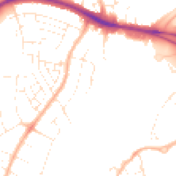
Daytime· 07:00 – 23:00
48.5dB

Everything within walking distance
Schools, transport stops and scenic spots near this property — 52 points of interest in total.
Common questions
The questions buyers, sellers and homeowners most often ask about 34 Nutfield Grove, Filton, Bristol, BS34 7LJ. Each answer is also embedded as structured data for search engines.
