Are you a property professional?Get qualified leads from motivated homeowners.
Get started11 Park Avenue, Ramsbottom, Bury, BL0 0DA
3 sales on record
About 11 Park Avenue
A plain-English summary derived from public records, EPC certificates, sold prices and local data.
11 Park Avenue is a three-bedroom semi-detached house in Ramsbottom, Bury, Bury (BL0 0DA). It has a recorded floor area of 89 m² (around 958 sq ft), construction records dating it to 1930-1949 and council tax band C. The latest certificate (June 2014) shows a D (score 63), on the cusp of jumping into the C band. The recommended improvements would lift it to B (score 85), a 2-band jump. The latest certificate is from June 2014, so improvements made since then won't be reflected.
Sale prices here have outpaced Bury HPI: 3.7% per year against 0% for the wider region. Today's modelled estimate of £314,000 is 35.3% above the 2018 sale price. On a £-per-square-foot basis, the last sale (£242/sq ft) was about 28.1% above the typical sold price in the postcode. One planning record on file: an extension approved in 2019. Past consents include an extension and a porch, meaningful when judging how the property has evolved. Last changed hands 8 years ago, in February 2018. At 89 m² it's 16.9% smaller than the typical home in the postcode (107 m² median across 6 EPCs).
What this property has
Pulled from EPC certificates, claim submissions and our property model. Empty categories are hidden — we only show what's known.
Inside
- Bedrooms3
- Bathrooms1
Energy performance
Every EPC certificate filed against this property — current rating, recorded improvements, and where there's headroom to reach a higher band.
Recommended upgrades on file would lift this property by multiple EPC bands.
EPC Expired
This certificate is over 10 years old and is no longer valid.Expired 09 Jun 2024
Planning history
Applications and permits filed against 11 Park Avenue, Ramsbottom, Bury, BL0 0DA, sourced from the PlanIt planning register.
11 Park Avenue has an approved side and rear extension on the planning record.
- Jan 2019PorchFullApprove with Conditions
Extension: Side and rear of property
Single storey extension at side/rear and front porch
Sales history & valuation
Recorded transactions, our model's current estimate, and a quick read on what neighbouring properties have sold for.
11 Park Avenue valuation sits well clear of the typical sold price in this postcode.
Current estimate
See how we calculated this£314,000
Modelled from EPC, postcode comparables and a sale-price growth of 3.7% per year over 15 years.
Last sold (2018)
£232,000
Growth on file: 3.7% per year over 15 years.
Sales timeline
Versus other Park Avenue homes
Four headline reads against 6 similar houses on this street, drawn from the latest EPC and Land Registry data.
Floor Area for 11 Park Avenue lags the street by a wide margin.
Price per m²
£2,607
Street avg £2,658
Floor Area
89 m²
Street avg 117 m²
Habitable Rooms
5 rooms
Street avg 5 rooms
Similar properties nearby
A handful of close matches in the same postcode area, ranked by likeness on bedrooms, type and floor area.
The neighbourhood at a glance
A condensed read of the local area. Each tile links through to the full breakdown on the Bury district page.
Rail-style transport is unusually close for this postcode.
Crime
3/mo
Steady year-on-year across the wider district.
Nearest stop
0.1 km
Fletcher Close — bus stop.
Road noise across the postcode
Modelled day and night-time noise levels around BL0 0DA from Defra's strategic mapping. The pin marks this postcode's centroid.
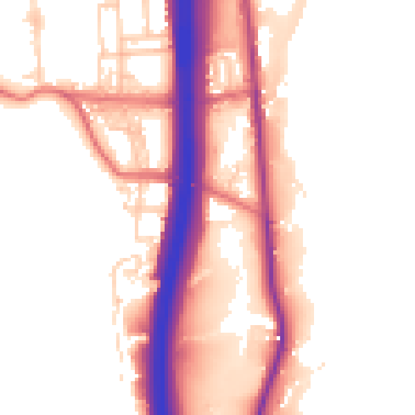
Daytime· 07:00 – 23:00
54.1dB

Everything within walking distance
Schools, transport stops and scenic spots near this property — 40 points of interest in total.
Beautiful places to visit nearby
Curated scenic spots within reach of this postcode, served by Beautifulplaces.ai. Photography and tagging come from their open dataset.
Common questions
The questions buyers, sellers and homeowners most often ask about 11 Park Avenue, Ramsbottom, Bury, BL0 0DA. Each answer is also embedded as structured data for search engines.