19 Court Road, Bournemouth, BH9 3DL
About 19 Court Road
19 Court Road is a property in Bournemouth (BH9 3DL). It has council tax band D.
It hasn't traded since July 1998, a hold of 28 years that's notably long for the area. One planning record on file: an extension approved in 2025. Past consents include an extension, meaningful when judging how the property has evolved. Across 1996–1998, sale prices on this property compounded at 14% per year.
Everything you need to know about 19 Court Road
The true value, the hidden risks and the full sale history, in one report.
Pick your report · every report is £14.99
One time fee only - money back guarantee

The data behind every report


Energy performance
No EPC on record
This property doesn't have an Energy Performance Certificate yet. An EPC is required to sell or let — and unlocks our automated valuation.
Get a survey for this property
Level 2 HomeBuyer Report
We've checked 10 risk factors against the available data for this property and believe a Level 2 HomeBuyer Report could be a suitable option for you.
Planning history
19 Court Road has an approved single-storey rear extension on the planning record.
1 application on record at 19 Court Road, Bournemouth, BH9 3DL
- Nov 2025ExtensionFullOutcome in report
Extension: Single storey · Rear of property
Proposed Single Storey Rear Extension
- Documents
- 7 docs on file
- Reference
- P/25/03965/HOU
Unlock 19 Court Road, Bournemouth, BH9 3DL's full planning history
You're seeing the shape of it. The report has the substance.
- Every decision — granted, refused or withdrawn (1 on record)
- All 1 application on this property in full, plus 1 notable nearby
- The 7 documents, officer reports & conditions
- What the pattern means for extending or converting here
One time fee only - money back guarantee
Sales history & valuation
£109,500
Growth on file: 14.0% per year over 2 years.
Sales timeline
30 July 1998Most recent
£109,500
+36.2%over 2 years19 March 1996
£80,400
Median price across the last 5 sales in BH9 3DL: £374,500 (2021–2019).
Nearby sales in BH9 3DL
Everything you need to know about 19 Court Road
The true value, the hidden risks and the full sale history, in one report.
Pick your report · every report is £14.99
One time fee only - money back guarantee
The data behind every report
Similar properties nearby
The neighbourhood at a glance
Daytime road noise here sits well below conversation level — a quiet pocket of the postcode.
Crime
4/mo
Steady year-on-year across the wider district.
Nearest stop
0.1 km
St Francis Church — bus stop.
Closest school
0.2 km
Queen's Park Academy. 27 schools nearby.
Go deeper on the local area
A Local Area report breaks down crime, transport links, schools and air quality in depth.
Road noise across the postcode
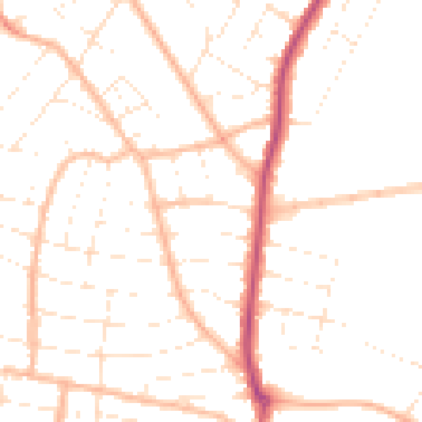
Daytime· 07:00 – 23:00
48.7dB

Night-time· 23:00 – 07:00
38.9dB