10 Chesildene Drive, Bournemouth, BH8 0BG
About 10 Chesildene Drive
10 Chesildene Drive is a two-bedroom detached house in Bournemouth (BH8 0BG). It has a recorded floor area of 81 m² (around 872 sq ft), construction records dating it to 1983-1990 and council tax band D. The latest certificate (September 2024) shows a C (score 70). The recommended improvements would push it to B (score 85).
Its energy rating outperforms most of the postcode (better than 75% of similar EPCs). Across 1999–2024, sale prices on this property compounded at 5% per year. On a £-per-square-foot basis, the last sale (£444/sq ft) was about 56.5% above the typical sold price in the postcode. Most recent transfer: November 2024 at £387,500.
What this property has
Inside
- Bedrooms2
- Bathrooms1
Outside
- Private gardenRear
- GarageIntegral
Everything you need to know about 10 Chesildene Drive
The true value, the hidden risks and the full sale history, in one report.
Pick your report · every report is £14.99
One time fee only - money back guarantee

The data behind every report


Energy performance
EPC Rating
Get a survey for this property
Level 2 HomeBuyer Report
We've checked 10 risk factors against the available data for this property and believe a Level 2 HomeBuyer Report could be a suitable option for you.
From £695 · Includes VAT
Planning history
10 Chesildene Drive has no planning applications on record.
A planning report still maps activity across the surrounding area and reads this property's extension & conversion potential.
Sales history & valuation
Latest sale on 10 Chesildene Drive was the highest on Land Registry record across the postcode.
£402,000
Modelled from EPC, postcode comparables and a sale-price growth of 5.0% per year over 25 years.
£387,500
Growth on file: 5.0% per year over 25 years.
Sales timeline
14 November 2024Most recent
£387,500
+239.9%over 25 years23 August 1999
£114,000
Median price across the last 5 sales in BH8 0BG: £335,000 (2023–2017).
Nearby sales in BH8 0BG
2 Chesildene Drive, Bournemouth, BH8 0BG
Sold Dec 2023
£350,0006 Chesildene Drive, Bournemouth, BH8 0BG
Sold Sept 2023
£335,00016 Chesildene Drive, Bournemouth, BH8 0BG
Sold Oct 2018
£257,00014 Chesildene Drive, Bournemouth, BH8 0BG
Sold Dec 2017
£287,50012 Chesildene Drive, Bournemouth, BH8 0BG
Sold Jul 2017
£350,000
Versus other Chesildene Drive homes
Years Held for 10 Chesildene Drive lags the street by a wide margin.
Price per m²
£4,784
Street avg £3,865
Floor Area
81 m²
Street avg 75 m²
Habitable Rooms
4 rooms
Street avg 4 rooms
CO₂ Emissions
2.8 t/year
Street avg 3.1 t/year
Everything you need to know about 10 Chesildene Drive
The true value, the hidden risks and the full sale history, in one report.
Pick your report · every report is £14.99
One time fee only - money back guarantee
The data behind every report
Similar properties nearby
1 Downton Close
BH8 0EP
1 Bucklers Way
BH8 0EW
1 Ashurst Road
BH8 0NW
1 Barrowgate Way
BH8 0HD
1 Culford Close
BH8 0HX
1 Braishfield Gardens
BH8 0QA
1 Calmore Close
BH8 0NN
1 Chesilbourne Grove
BH8 0BA
The neighbourhood at a glance
Daytime road noise here sits well below conversation level — a quiet pocket of the postcode.
Crime
14/mo
Steady year-on-year across the wider district.
Nearest stop
0.0 km
Seagrim Road — bus stop.
Closest school
0.3 km
Muscliff Primary School. 20 schools nearby.
Go deeper on the local area
A Local Area report breaks down crime, transport links, schools and air quality in depth.
Road noise across the postcode
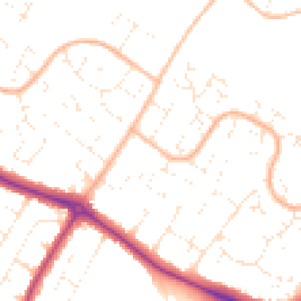
Daytime· 07:00 – 23:00
49.9dB

Night-time· 23:00 – 07:00
39.5dB