19 Seagrim Road, Bournemouth, BH8 0AY
About 19 Seagrim Road
19 Seagrim Road is a mid-terrace house in Bournemouth (BH8 0AY). It has a recorded floor area of 67 m² (around 721 sq ft), construction records dating it to 2003-2006 and council tax band C. The latest certificate (July 2025) shows a C (score 71).
Held since May 2007 — that's 19 years off the open market, well above the local norm. That sale landed at the peak of the pre-credit-crunch market, which is a useful reference point when interpreting the price. Today's modelled estimate of £265,000 sits 345.4% above the 2007 sale of £59,500. On a £-per-square-foot basis, the last sale (£83/sq ft) was about 68.5% below the postcode norm. At 67 m² it's 17.3% smaller than the typical home in the postcode (81 m² median across 25 EPCs).
Everything you need to know about 19 Seagrim Road
The true value, the hidden risks and the full sale history, in one report.
Pick your report · every report is £14.99
One time fee only - money back guarantee

The data behind every report


Energy performance
EPC Rating
Get a survey for this property
Level 2 HomeBuyer Report
We've checked 10 risk factors against the available data for this property and believe a Level 2 HomeBuyer Report could be a suitable option for you.
From £545 · Includes VAT
Planning history
19 Seagrim Road has no planning applications on record.
A planning report still maps activity across the surrounding area and reads this property's extension & conversion potential.
Sales history & valuation
Latest sale on 19 Seagrim Road was the lowest on Land Registry record across the postcode.
£265,000
Modelled from EPC, postcode comparables.
£59,500
Recorded with HM Land Registry.
Sales timeline
30 May 2007Most recent
£59,500
Median price across the last 5 sales in BH8 0AY: £315,000 (2025–2007).
Nearby sales in BH8 0AY
Versus other Seagrim Road homes
19 Seagrim Road is notably below the street on price per m².
Price per m²
£888
Street avg £3,769
Floor Area
67 m²
Street avg 83 m²
Habitable Rooms
5 rooms
Street avg 4 rooms
CO₂ Emissions
2.2 t/year
Street avg 2.3 t/year
Everything you need to know about 19 Seagrim Road
The true value, the hidden risks and the full sale history, in one report.
Pick your report · every report is £14.99
One time fee only - money back guarantee
The data behind every report
Similar properties nearby
The neighbourhood at a glance
Daytime road noise here sits well below conversation level — a quiet pocket of the postcode.
Crime
14/mo
Steady year-on-year across the wider district.
Nearest stop
0.1 km
Hungerford Road — bus stop.
Closest school
0.5 km
Muscliff Primary School. 21 schools nearby.
Go deeper on the local area
A Local Area report breaks down crime, transport links, schools and air quality in depth.
Road noise across the postcode
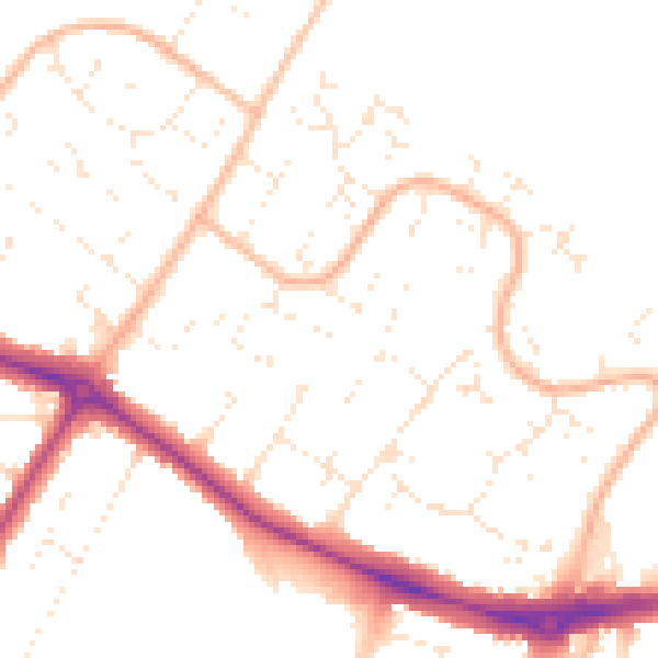
Daytime· 07:00 – 23:00
49.9dB

Night-time· 23:00 – 07:00
39.8dB