18 Bradley Street, Bradford, BD9 4LL
About 18 Bradley Street
18 Bradley Street is a two-bedroom mid-terrace house in Bradford (BD9 4LL). It has a recorded floor area of 59 m² (around 635 sq ft), construction records dating it to before 1900 and council tax band A. Tenure is freehold. The latest certificate (September 2023) shows a D (score 64), on the cusp of jumping into the C band. The recommended improvements would lift it to B (score 89), a 2-band jump.
Today's modelled estimate of £122,000 sits 64.9% above the 2024 sale of £74,000. Sold March 2024 for £74,000.
What this property has
Inside
- Bedrooms2
- Bathrooms1
- EnsuiteYes
Outside
- Private gardenYes
Building
- TenureFreehold
Everything you need to know about 18 Bradley Street
The true value, the hidden risks and the full sale history, in one report.
30-day money-back guarantee

The data behind every report


Energy performance
Recommended upgrades on file would lift this property by multiple EPC bands.
EPC Rating
Planning history
18 Bradley Street has no planning applications on record.
Notable planning nearby
5applications of note in the surrounding area
We flagged 1 thing worth checking at 18 Bradley Street
Independent checks surfaced things a buyer would want to understand before offering. The report explains each one in full, with the underlying data and what to ask.
- Signs of HMO activity in the area
30-day money-back guarantee
Sales history & valuation
18 Bradley Street valuation sits well clear of the typical sold price in this postcode.
£122,000
Modelled from EPC, postcode comparables.
£74,000
Recorded with HM Land Registry.
Sales timeline
20 March 2024Most recent
£74,000
Median price across the last 5 sales in BD9 4LL: £100,000 (2025–2023).
Nearby sales in BD9 4LL
Versus other Bradley Street homes
18 Bradley Street outperforms the street on co₂ emissions by a wide margin.
Price per m²
£1,254
Street avg £1,395
Floor Area
59 m²
Street avg 63 m²
Habitable Rooms
3 rooms
Street avg 4 rooms
CO₂ Emissions
3.1 t/year
Street avg 3.7 t/year
Everything you need to know about 18 Bradley Street
The true value, the hidden risks and the full sale history, in one report.
30-day money-back guarantee
The data behind every report
Similar properties nearby
1 Firth Road
BD9 4RS
1 Milford Place
BD9 4RU
1 Frizley Gardens
BD9 4LY
1 Bradley Street
BD9 4LL
1 Garth Barn Close
BD9 4BG
1 Aireville Crescent
BD9 4EU
1 Aireville Rise
BD9 4ES
1 Lynthorne Road
BD9 4EZ
The neighbourhood at a glance
Rail-style transport is unusually close for this postcode.
Crime
8/mo
Rising year-on-year across the wider district.
Nearest stop
0.1 km
Park Grove — bus stop.
Closest school
0.3 km
Frizinghall Primary School. 49 schools nearby.
Go deeper on the local area
The full report breaks down crime, transport links, schools and air quality in depth.
Road noise across the postcode
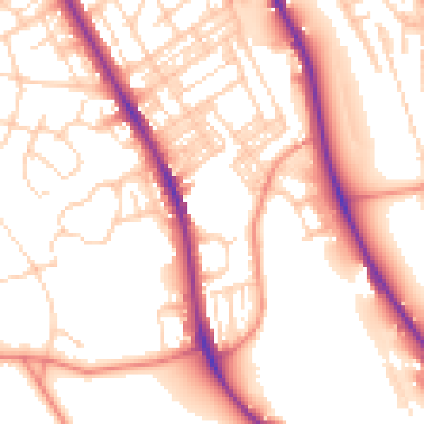
Daytime· 07:00 – 23:00
54.5dB

Night-time· 23:00 – 07:00
45.0dB