24 City Mills, Skeldergate, York, YO1 6DB
About 24 City Mills
24 City Mills is an end-of-terrace house in York (YO1 6DB). It has a recorded floor area of 58 m² (around 624 sq ft), construction records dating it to 1991-1995 and council tax band C. At 58 m² this is the 16th smallest of 21 units on EPC record in the building, where floor areas span 40–116 m². The building's EPC ratings span E to C, with this unit at the top. The latest certificate (March 2025) shows a C (score 78), near the top of the C band.
Everything you need to know about 24 City Mills
The true value, the hidden risks and the full sale history, in one report.
30-day money-back guarantee

The data behind every report


Energy performance
EPC Rating
Planning history
24 City Mills has no planning applications on record.
Notable planning nearby
10applications of note in the surrounding area
We flagged 3 things worth checking at 24 City Mills
Independent checks surfaced things a buyer would want to understand before offering. The report explains each one in full, with the underlying data and what to ask.
- Signs of HMO activity in the area
- Larger development activity nearby
- Environmental risk flagged
30-day money-back guarantee
Sales history & valuation
24 City Mills has no Land Registry sales on file, suggesting it has stayed in the same hands since registration began.
£204,000
Modelled from EPC, postcode comparables.
No sales recorded with HM Land Registry
That can mean the property has never traded since the registry began publishing in 1995, was a new build that hasn't been registered yet, or is held in the same hands long-term.
Versus other City Mills homes
EPC Rating for 24 City Mills runs comfortably ahead of the street norm.
EPC Rating
78 (C)
Street avg 71 (C)
Floor Area
58 m²
Street avg 56 m²
CO₂ Emissions
1.6 t/year
Street avg 2.0 t/year
Habitable Rooms
2 rooms
Street avg 3 rooms
Everything you need to know about 24 City Mills
The true value, the hidden risks and the full sale history, in one report.
30-day money-back guarantee
The data behind every report
Similar properties nearby
1 Clifford House, Lady Anne Court, Skeldergate
YO1 6DT
1 Lambert Court
YO1 6HN
1 City Mills, Skeldergate
YO1 6DB
1 Bishophill Junior
YO1 6EN
1 Constantine House, Fetter Lane
YO1 6DF
1 Jacob Court, Trinity Lane
YO1 6LL
1 Queens Court, Fetter Lane
YO1 6EH
1 All Saints Cottages, North Street
YO1 6JD
The neighbourhood at a glance
Reported crime in the wider district is trending notably upward year-on-year.
Crime
5/mo
Rising year-on-year across the wider district.
Nearest stop
0.1 km
Tower Street — bus stop.
Closest school
0.5 km
Scarcroft Primary School. 30 schools nearby.
Go deeper on the local area
The full report breaks down crime, transport links, schools and air quality in depth.
Road noise across the postcode
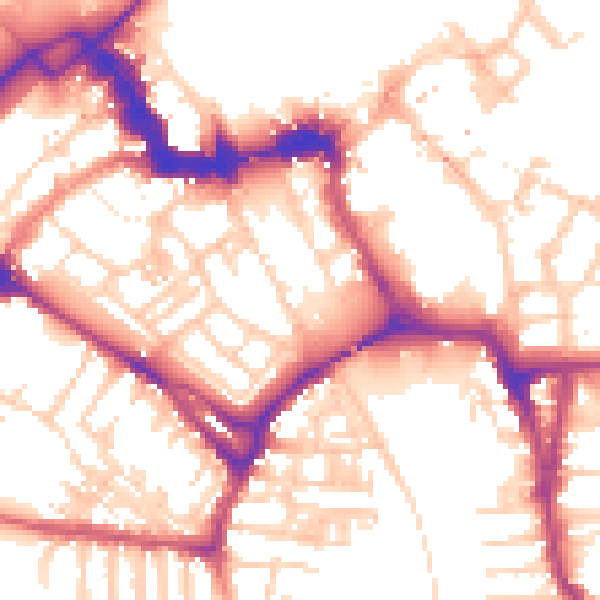
Daytime· 07:00 – 23:00
55.0dB
Night-time· 23:00 – 07:00
45.3dB