27 Arundel Street, Newtown, Wigan, WN5 9BQ
About 27 Arundel Street
27 Arundel Street is a two-bedroom mid-terrace house in Newtown, Wigan, Wigan (WN5 9BQ). It has a recorded floor area of 84 m² (around 904 sq ft), construction records dating it to before 1900 and council tax band A. The latest certificate (November 2025) shows a C (score 74). When first surveyed in May 2013 the rating was E, the property has climbed 2 bands since. Between certificates, wall efficiency went from Very Poor to Good, hot-water efficiency went from Very Poor to Good and lighting went from Poor to Very Good; while roof efficiency dropped from Very Good to Average and window efficiency dropped from Average to Poor.
Held since April 1996 — that's 30 years off the open market, well above the local norm. Only one transfer is on record with HM Land Registry, suggesting it has stayed in the same hands for a long time. Today's modelled estimate of £122,000 sits 617.6% above the 1996 sale of £17,000. On a £-per-square-foot basis, the last sale (£19/sq ft) was about 73.4% below the postcode norm. Its energy rating outperforms most of the postcode (better than 71% of similar EPCs).
What this property has
Inside
- Bedrooms2
- Bathrooms1
Outside
- Private gardenRear
Building
- RefurbishedYes
Everything you need to know about 27 Arundel Street
The true value, the hidden risks and the full sale history, in one report.
30-day money-back guarantee

The data behind every report


Energy performance
EPC Rating
Property Improvements
Changes detected from historical EPC data
Heating controls upgraded for better temperature management
Hot water system upgraded
Wall insulation improved
Heating controls changed
Hot water efficiency improved
Cavity wall insulation installed
Heating controls upgraded for better temperature management
Hot water system upgraded
Loft insulation installed or upgraded to 250mm+
More low energy lighting installed
Get a survey for this property
Level 3 Building Survey
Because the property was built before 1919, we believe a Level 3 building survey should be considered.
From £820 · Includes VAT
Planning history
27 Arundel Street has no planning applications on record.
Notable planning nearby
25applications of note in the surrounding area
We flagged 2 things worth checking at 27 Arundel Street
Independent checks surfaced things a buyer would want to understand before offering. The report explains each one in full, with the underlying data and what to ask.
- Signs of HMO activity in the area
- Larger development activity nearby
30-day money-back guarantee
Sales history & valuation
27 Arundel Street's modelled value sits at over four times its earliest registered sale price (1996).
£122,000
Modelled from EPC, postcode comparables.
£17,000
Recorded with HM Land Registry.
Sales timeline
11 April 1996Most recent
£17,000
Median price across the last 5 sales in WN5 9BQ: £115,000 (2025–2022).
Nearby sales in WN5 9BQ
34 Arundel Street, Newtown, Wigan, WN5 9BQ
Sold Feb 2025
£109,00014 Arundel Street, Newtown, Wigan, WN5 9BQ
Sold Sept 2024
£115,0007 Arundel Street, Newtown, Wigan, WN5 9BQ
Sold Nov 2023
£142,0005 Arundel Street, Newtown, Wigan, WN5 9BQ
Sold Sept 2023
£157,00031 Arundel Street, Newtown, Wigan, WN5 9BQ
Sold Oct 2022
£110,000
Versus other Arundel Street homes
27 Arundel Street outperforms the street on years held by a wide margin.
Price per m²
£202
Street avg £961
Floor Area
84 m²
Street avg 82 m²
Habitable Rooms
4 rooms
Street avg 4 rooms
CO₂ Emissions
2.5 t/year
Street avg 4.0 t/year
Everything you need to know about 27 Arundel Street
The true value, the hidden risks and the full sale history, in one report.
30-day money-back guarantee
The data behind every report
Similar properties nearby
1 Callander Court
WN5 9RW
1 Argyll Street
WN5 9BG
1 Alker Street
WN5 9BW
1 Arundel Street, Newtown
WN5 9BQ
1 Bulteel Street
WN5 9NT
1 Claude Street
WN5 9QP
1 Bramble Grove
WN5 9PR
1 Campbell Street
WN5 9HT
The neighbourhood at a glance
Crime
2/mo
Steady year-on-year across the wider district.
Nearest stop
0.1 km
St Mark's Church — bus stop.
Closest school
0.3 km
St Mark's CofE Primary School. 28 schools nearby.
Go deeper on the local area
The full report breaks down crime, transport links, schools and air quality in depth.
Road noise across the postcode
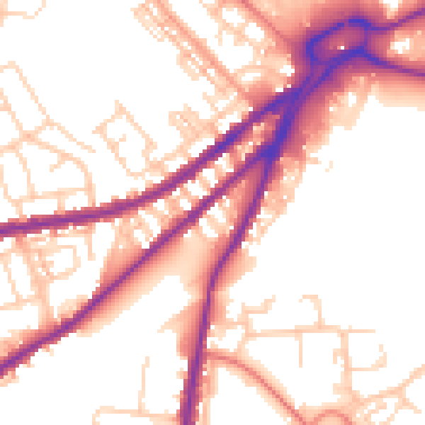
Daytime· 07:00 – 23:00
54.5dB

Night-time· 23:00 – 07:00
46.1dB