Kirklees, Ropewalk, Knottingley, WF11 9AL
About Kirklees
A plain-English summary derived from public records, EPC certificates, sold prices and local data.
Kirklees is a detached house in Knottingley (WF11 9AL). It has a recorded floor area of 196 m² (around 2105 sq ft) and council tax band E. The latest certificate (October 2009) shows an F (score 32), near the bottom of the EPC scale. The latest certificate is from October 2009, so improvements made since then won't be reflected.
Untraded for 20 years, with the last transfer in July 2006. Sale prices here have outpaced England HPI: 18.6% per year against 0% for the wider region. Today's modelled estimate of £518,000 sits 95.5% above the 2006 sale of £265,000. At 196 m² it's 26.2% larger than the typical home in the postcode (155 m² median across 4 EPCs). On energy efficiency it sits in the bottom 10% of properties in this postcode — significant headroom for improvement.
Before you offer
Know exactly what you're buying at Kirklees
Before you offer, see what the listing won't tell you, the true value, the red flags and the full history.
Already flagged here
Larger development activity nearby
£9.99£14.99
Launch offer · save £5
Energy performance
Every EPC certificate filed against this property — current rating, recorded improvements, and where there's headroom to reach a higher band.
Kirklees sits at the bottom of the postcode for energy efficiency — meaningful headroom to improve.
EPC Expired
This certificate is over 10 years old and is no longer valid.Expired 23 Oct 2019
Planning history
Applications and permits filed against Kirklees, Ropewalk, Knottingley, WF11 9AL, sourced from the PlanIt planning register.
Kirklees has no planning applications on record.
Notable planning nearby
4applications of note in the surrounding area
Before you offer
We flagged 1 thing worth checking at Kirklees
Independent checks surfaced things a buyer would want to understand before offering. The report explains each one in full, with the underlying data and what to ask.
- Larger development activity nearby
£9.99£14.99
30-day money-back guarantee
Sales history & valuation
Recorded transactions, our model's current estimate, and a quick read on what neighbouring properties have sold for.
Kirklees has more than doubled in price since the earliest registered sale in 2000.
Current estimate
See how we calculated this£518,000
Modelled from EPC, postcode comparables and a sale-price growth of 18.6% per year over 6 years.
Last sold (2006)
£265,000
Growth on file: 18.6% per year over 6 years.
Sales timeline
Before you offerLaunch offer · save £5
Everything we know about Kirklees, in one report
What it's really worth, what could be wrong, and the planning, sales and area data in full.
What we flagged
- Larger development activity nearby
£9.99£14.99
Versus other Ropewalk homes
Four headline reads against 4 similar houses on this street, drawn from the latest EPC and Land Registry data.
Price per m² for Kirklees lags the street by a wide margin.
Price per m²
£1,355
Street avg £1,938
Floor Area
196 m²
Street avg 150 m²
Habitable Rooms
7 rooms
Street avg 7 rooms
Similar properties nearby
A handful of close matches in the same postcode area, ranked by likeness on bedrooms, type and floor area.
The neighbourhood at a glance
A condensed read of the local area. Each tile links through to the full breakdown on the Knottingley district page.
Daytime road noise here sits well below conversation level — a quiet pocket of the postcode.
Crime
5/mo
Steady year-on-year across the wider district.
Nearest stop
0.1 km
Road noise across the postcode
Modelled day and night-time noise levels around WF11 9AL from Defra's strategic mapping. The pin marks this postcode's centroid.
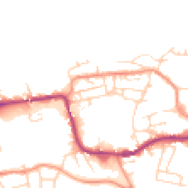
Daytime· 07:00 – 23:00
49.0dB

Everything within walking distance
Schools, transport stops and scenic spots near this property — 37 points of interest in total.
Common questions
The questions buyers, sellers and homeowners most often ask about Kirklees, Ropewalk, Knottingley, WF11 9AL. Each answer is also embedded as structured data for search engines.
