Elmdon House, Ropewalk, Knottingley, WF11 9AL
About Elmdon House
A plain-English summary derived from public records, EPC certificates, sold prices and local data.
Elmdon House is a four-bedroom detached house in Knottingley (WF11 9AL). It has a recorded floor area of 139 m² (around 1496 sq ft) and construction records dating it to 1900-1929. The latest certificate (March 2014) shows an E (score 42), well below the UK norm with real room to improve. The recommended improvements would lift it to C (score 79), a 2-band jump. The latest certificate is from March 2014, so improvements made since then won't be reflected. Other recorded features include attached land beyond the plot. Period features are noted in the property record. The home occupies a corner plot.
Sale prices here have outpaced England HPI: 5.7% per year against 0% for the wider region. Today's modelled estimate of £350,000 is 30.8% above the 2015 sale price. On a £-per-square-foot basis, the last sale (£179/sq ft) was about 38.4% above the typical sold price in the postcode. Last sold in December 2015, so it's been off the market for around 10 years. At 139 m² it's 24.2% smaller than the typical home in the postcode (183 m² median across 4 EPCs).
What this property has
Pulled from EPC certificates, claim submissions and our property model. Empty categories are hidden — we only show what's known.
Inside
- Bedrooms4
- Bathrooms1
- Dining roomYes
- EnsuiteYes
Energy performance
Every EPC certificate filed against this property — current rating, recorded improvements, and where there's headroom to reach a higher band.
Elmdon House's carbon output runs well above what efficient homes in the postcode produce.
EPC Expired
This certificate is over 10 years old and is no longer valid.Expired 12 Mar 2024
Planning history
Applications and permits filed against Elmdon House, Ropewalk, Knottingley, WF11 9AL, sourced from the PlanIt planning register.
No planning applications are recorded against Elmdon House, Ropewalk, Knottingley, WF11 9AL. The full report also covers planning activity across the surrounding area.
Full planning data for Elmdon House, Ropewalk, Knottingley, WF11 9AL
Every application and decision on this property and nearby, in full, in the report.
Sales history & valuation
Recorded transactions, our model's current estimate, and a quick read on what neighbouring properties have sold for.
Elmdon House has more than doubled in price since the earliest registered sale in 1998.
Current estimate
See how we calculated this£350,000
Modelled from EPC, postcode comparables and a sale-price growth of 5.7% per year over 18 years.
Last sold (2015)
£267,500
Growth on file: 5.7% per year over 18 years.
Sales timeline
Launch offer · 33% off
The complete analysis of Elmdon House, Ropewalk, Knottingley, WF11 9AL
Everything we know about this property, compiled into one in-depth, downloadable report.
Detailed analysis
A written breakdown of everything that matters
Versus other Ropewalk homes
Four headline reads against 4 similar houses on this street, drawn from the latest EPC and Land Registry data.
On price per m², Elmdon House stands well clear of the street.
Price per m²
£1,924
Street avg £1,796
Floor Area
139 m²
Street avg 164 m²
Habitable Rooms
7 rooms
Street avg 7 rooms
Similar properties nearby
A handful of close matches in the same postcode area, ranked by likeness on bedrooms, type and floor area.
The neighbourhood at a glance
A condensed read of the local area. Each tile links through to the full breakdown on the Knottingley district page.
Daytime road noise here sits well below conversation level — a quiet pocket of the postcode.
Crime
5/mo
Steady year-on-year across the wider district.
Nearest stop
0.1 km
Road noise across the postcode
Modelled day and night-time noise levels around WF11 9AL from Defra's strategic mapping. The pin marks this postcode's centroid.
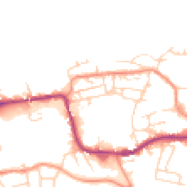
Daytime· 07:00 – 23:00
49.0dB

Everything within walking distance
Schools, transport stops and scenic spots near this property — 37 points of interest in total.
Common questions
The questions buyers, sellers and homeowners most often ask about Elmdon House, Ropewalk, Knottingley, WF11 9AL. Each answer is also embedded as structured data for search engines.
