21 Chestnut Avenue, Rickmansworth, WD3 4HA
About 21 Chestnut Avenue
21 Chestnut Avenue is a detached house in Rickmansworth (WD3 4HA). It has a recorded floor area of 449 m² (around 4833 sq ft) and construction records dating it to 2012 onwards. The latest certificate (April 2025) returns a B (score 82), comfortably above the UK average. The rating has held steady at B across 2 certificates since February 2015. Between certificates, roof efficiency went from Good to Very Good.
It hasn't traded since December 2003, a hold of 22 years that's notably long for the area. 12 planning records sit against the property, 8 approved, 1 refused, 2 pending. Past consents include an extension and partial demolition, meaningful when judging how the property has evolved. An active application for an extension is awaiting a decision. At 449 m² the property is well over the postcode median (201 m² across 16 EPCs), placing it in the larger end of the local stock. On energy efficiency it sits in the top 10% of properties in this postcode. Across 2000–2003, sale prices on this property compounded at 9.3% per year. Today's modelled estimate of £2,811,000 sits 325.9% above the 2003 sale of £660,000. On a £-per-square-foot basis, the last sale (£137/sq ft) was about 51.3% below the postcode norm.
Know exactly what you're buying at 21 Chestnut Avenue
Before you offer, see what the listing won't tell you, the true value, the red flags and the full history.
Valuation
against the asking price
Risks
planning & flood
Sold prices
similar homes nearby
Trends
the local market
Energy performance
21 Chestnut Avenue ranks among the most efficient homes in the postcode for energy use.
EPC Rating
Property Improvements
Changes detected from historical EPC data
Loft insulation upgraded to recommended levels
Solar PV panels (5 kWp) installed
Planning history
There is a planning application currently awaiting a decision.
- Jun 2025ExtensionFullIn report
Construction of two storey front extension and single storey rear extension, alterations to rear fenestration and associated alterations to rear patio
- Documents
- 10 docs on file
- Reference
- 25/1025/FUL
- Jun 2025ConditionsIn report
Discharge of Condition 4 (Tree Protection) pursuant to planning permission 25/0151/FUL
- Documents
- 2 docs on file
- Reference
- 25/0952/DIS
What's in 21 Chestnut Avenue, Rickmansworth, WD3 4HA's planning history?
10 more on this property, plus refusals, disputes and full decisions nearby, in the report.
Sales history & valuation
21 Chestnut Avenue's modelled value sits at over four times its earliest registered sale price (2000).
£2,811,000
Modelled from EPC, postcode comparables and a sale-price growth of 9.3% per year over 4 years.
£660,000
Growth on file: 9.3% per year over 4 years.
Sales timeline
12 December 2003Most recent
£660,000
+41.9%over 3 years6 January 2000
£465,000
Median price across the last 5 sales in WD3 4HA: £1,470,000 (2023–2021).
Nearby sales in WD3 4HA
41 Chestnut Avenue, Rickmansworth, WD3 4HA
Sold Jan 2023
£1,180,00031 Chestnut Avenue, Rickmansworth, WD3 4HA
Sold Nov 2021
£1,710,00025 Chestnut Avenue, Rickmansworth, WD3 4HA
Sold Mar 2021
£1,510,00049 Chestnut Avenue, Rickmansworth, WD3 4HA
Sold Feb 2021
£980,00035 Chestnut Avenue, Rickmansworth, WD3 4HA
Sold Feb 2021
£1,470,000
Everything we know about 21 Chestnut Avenue, in one report
What it's really worth, what could be wrong, and the planning, sales and area data in full.
- Am I paying too much?
- Is something wrong with it?
- Is the agent's story true?
- Will it hold its value?

Versus other Chestnut Avenue homes
21 Chestnut Avenue outperforms the street on epc rating by a wide margin.
Price per m²
£1,470
Street avg £5,028
Floor Area
449 m²
Street avg 230 m²
Habitable Rooms
10 rooms
Street avg 8 rooms
CO₂ Emissions
7.8 t/year
Street avg 8.5 t/year
Similar properties nearby
1 Hayward Copse, Loudwater
WD3 4GX
1 Lower Plantation, Loudwater
WD3 4PQ
1 High Close
WD3 4DZ
1 Armitage Close, Loudwater
WD3 4HL
1 Goosefields
WD3 4BE
1 Spencer Walk
WD3 4EE
1 Greenhills Close
WD3 4BW
1 Hillpoint, Loudwater
WD3 4HW
The neighbourhood at a glance
Crime
8/mo
Steady year-on-year across the wider district.
Nearest stop
0.3 km
The Clump — bus stop.
Closest school
0.7 km
Arnett Hills Junior Mixed and Infant School. 14 schools nearby.
Go deeper on the local area
The full report breaks down crime, transport links, schools and air quality in depth.
Road noise across the postcode
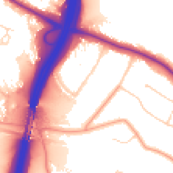
Daytime· 07:00 – 23:00
56.6dB

Night-time· 23:00 – 07:00
49.0dB