20 Clitheroe Gardens, Watford, WD19 6RP
About 20 Clitheroe Gardens
20 Clitheroe Gardens is a property in Watford (WD19 6RP). It has a recorded floor area of 45 m² (around 484 sq ft), construction records dating it to 1950-1966 and council tax band C. At 45 m² this is the 17th smallest of 27 units on EPC record in the building, where floor areas span 34–77 m². The building's EPC ratings span D to B, with this unit at the bottom. The latest certificate (November 2025) shows a D (score 66), on the cusp of jumping into the C band. The recommended improvements would push it to C (score 74). This certificate was lodged in the last six months, so the rating reflects current condition.
At 45 m² it's 26.8% larger than the typical home in the postcode (36 m² median across 26 EPCs).
Everything you need to know about 20 Clitheroe Gardens
The true value, the hidden risks and the full sale history, in one report.
30-day money-back guarantee

The data behind every report


Energy performance
The EPC has just been inspected, so the rating reflects current condition.
EPC Rating
Planning history
20 Clitheroe Gardens has no planning applications on record.
Notable planning nearby
4applications of note in the surrounding area
We flagged 1 thing worth checking at 20 Clitheroe Gardens
Independent checks surfaced things a buyer would want to understand before offering. The report explains each one in full, with the underlying data and what to ask.
- Larger development activity nearby
30-day money-back guarantee
Sales history & valuation
20 Clitheroe Gardens has no Land Registry sales on file, suggesting it has stayed in the same hands since registration began.
£224,000
Modelled from EPC, postcode comparables.
No sales recorded with HM Land Registry
That can mean the property has never traded since the registry began publishing in 1995, was a new build that hasn't been registered yet, or is held in the same hands long-term.
Versus other Clitheroe Gardens homes
20 Clitheroe Gardens is notably below the street on floor area.
EPC Rating
66 (D)
Street avg 65 (D)
Floor Area
45 m²
Street avg 51 m²
CO₂ Emissions
2.1 t/year
Street avg 2.5 t/year
Habitable Rooms
2 rooms
Street avg 2 rooms
Everything you need to know about 20 Clitheroe Gardens
The true value, the hidden risks and the full sale history, in one report.
30-day money-back guarantee
The data behind every report
Similar properties nearby
The neighbourhood at a glance
Rail-style transport is unusually close for this postcode.
Crime
4/mo
Steady year-on-year across the wider district.
Nearest stop
0.1 km
Birstal Green — bus stop.
Closest school
0.3 km
Oxhey Wood Primary School. 25 schools nearby.
Go deeper on the local area
The full report breaks down crime, transport links, schools and air quality in depth.
Road noise across the postcode
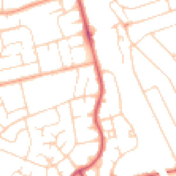
Daytime· 07:00 – 23:00
49.5dB

Night-time· 23:00 – 07:00
38.9dB