9 Carlton Road, Ealing, London, W4 5DY
About 9 Carlton Road
9 Carlton Road is a one-bedroom semi-detached house in Ealing, London, London (W4 5DY). It has a recorded floor area of 46 m² (around 495 sq ft), construction records dating it to 1950-1966 and council tax band C. The latest certificate (July 2020) shows an E (score 50), well below the UK norm with real room to improve. Earlier certificates rated it D (February 2010); the latest reading is one band lower. Between certificates, lighting dropped from Average to Very Poor. The recommended improvements would push it to D (score 65). At 46 m² this is the 4th smallest of 45 units on EPC record in the building, where floor areas span 44–147 m². The building's EPC ratings span F to B across 45 units on file.
One planning record on file: new windows approved in 2023. Past consents include new windows, meaningful when judging how the property has evolved. It lags the bulk of the postcode on energy efficiency (less efficient than 84% of similar EPCs). Across 2007–2018, sale prices on this property compounded at 3.3% per year. On a £-per-square-foot basis, the last sale (£717/sq ft) was about 64.8% above the typical sold price in the postcode. Last changed hands 8 years ago, in February 2018.
What this property has
Inside
- Bedrooms1
- Bathrooms1
Everything you need to know about 9 Carlton Road
The true value, the hidden risks and the full sale history, in one report.
Pick your report · every report is £14.99
Every report £14.99, one-off · 30-day money-back guarantee · emailed in minutes

The data behind every report







Energy performance
EPC Rating

Get a survey for this property
Level 2 HomeBuyer Report
We've checked 10 risk factors against the available data for this property and believe a Level 2 HomeBuyer Report could be a suitable option for you.
From £595 · Includes VAT
Planning history
1 application on record at 9 Carlton Road, Ealing, London, W4 5DY
- May 2023FullOutcome in report
Replacement of windows (Joint Application; Regulation 3 Application by London Borough of Ealing)
New Windows- Documents
- 14 docs on file
- Reference
- 231335FUL
Unlock 9 Carlton Road, Ealing, London, W4 5DY's full planning history
You're seeing the shape of it. The report has the substance.
- Every decision — granted, refused or withdrawn (1 on record)
- All 1 application on this property in full, plus 10 notable nearby
- The 14 documents, officer reports & conditions
- What the pattern means for extending or converting here
30-day money-back guarantee
Sales history & valuation
£358,000
Modelled from EPC, postcode comparables and a sale-price growth of 3.3% per year over 11 years.
£355,000
Growth on file: 3.3% per year over 11 years.
Sales timeline
16 February 2018Most recent
£355,000
+68.2%over 7 years9 August 2010
£211,000
-15.6%over 3 years16 March 2007
£249,950
Median price across the last 5 sales in W4 5DY: £925,000 (2025–2023).
Nearby sales in W4 5DY
13 Carlton Road, Ealing, London, W4 5DY
Sold Jan 2025
£1,185,00015 Carlton Road, Ealing, London, W4 5DY
Sold Oct 2024
£925,0001 Carlton Road, Ealing, London, W4 5DY
Sold Sept 2024
£265,00033 Carlton Road, Ealing, London, W4 5DY
Sold Aug 2023
£1,060,00085 Carlton Road, Ealing, London, W4 5DY
Sold Jul 2023
£281,000
Versus other Carlton Road homes
EPC Rating for 9 Carlton Road lags the street by a wide margin.
Price per m²
£7,717
Street avg £6,203
Floor Area
46 m²
Street avg 53 m²
Habitable Rooms
2 rooms
Street avg 3 rooms
CO₂ Emissions
3.5 t/year
Street avg 2.3 t/year
Everything you need to know about 9 Carlton Road
The true value, the hidden risks and the full sale history, in one report.
Pick your report · every report is £14.99
Every report £14.99, one-off · 30-day money-back guarantee · emailed in minutes
The data behind every report
Similar properties nearby
1 Carlton Road, Ealing
W4 5DY
1 Beaulieu Place, Ealing
W4 5SY
1 Antrobus Road, Ealing
W4 5HY
1 Clovelly Road, Ealing
W4 5DU
1 Alfred Close, Hounslow
W4 5UW
1 Copenhagen Gardens, Ealing
W4 5NN
1 Copper Mews, Ealing
W4 5AQ
1 Bridgman Road, Ealing
W4 5BA
The neighbourhood at a glance
Rail-style transport is unusually close for this postcode.
Crime
10/mo
Rising year-on-year across the wider district.
Nearest stop
0.2 km
Wilkinson Way — bus stop.
Closest school
0.4 km
Southfield Primary School. 51 schools nearby.
Go deeper on the local area
A Local Area report breaks down crime, transport links, schools and air quality in depth.
Road noise across the postcode
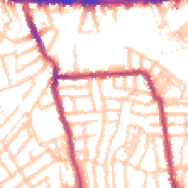
Daytime· 07:00 – 23:00
53.4dB

Night-time· 23:00 – 07:00
42.6dB