Are you a property professional?Get qualified leads from motivated homeowners.
Get started61 Bushy Park Road, Teddington, TW11 9DQ
EPC B
About 61 Bushy Park Road
A plain-English summary derived from public records, EPC certificates, sold prices and local data.
61 Bushy Park Road is a two-bedroom detached house in Teddington (TW11 9DQ). It has a recorded floor area of 93 m² (around 1001 sq ft), construction records dating it to 1900-1929 and council tax band F. The latest certificate (June 2017) returns a high B (score 87), putting the home a stone's throw from an A rating. When first surveyed in February 2015 the rating was E, the property has climbed 3 bands since. Between certificates, wall efficiency went from Very Poor to Very Good, roof efficiency went from Very Poor to Very Good and window efficiency went from Very Poor to Very Good. At 93 m² this is the 11th smallest of 24 units on EPC record in the building, where floor areas span 70–192 m². The building's EPC ratings span F to B, with this unit at the top. The property has solar panels on record, all of which lower running costs and tend to lift resale appeal. Other recorded features include a loft.
Sale prices here have outpaced England HPI: 2.2% per year against 0% for the wider region. Today's modelled estimate of £931,000 sits 59.1% above the 2023 sale of £585,000. On a £-per-square-foot basis, the last sale (£584/sq ft) was about 46.6% above the typical sold price in the postcode. Its energy rating outperforms most of the postcode (better than 87% of similar EPCs). Last sale on file: £585,000 in August 2023. One historical planning record sits against the property in 2020.
What this property has
Pulled from EPC certificates, claim submissions and our property model. Empty categories are hidden — we only show what's known.
Inside
- Bedrooms2
- Bathrooms2
- EnsuiteYes
- LoftYes
Energy performance
Every EPC certificate filed against this property — current rating, recorded improvements, and where there's headroom to reach a higher band.
61 Bushy Park Road's carbon output is low for the local stock.
Current Certificate(1 of 2)
Jun 2017
EPC Rating
A
B
B87
C
D
E
F
G
Main Heating
Gas
Main Fuel
Gas
Hot Water
Good
Windows
Very Good
CO2 Emissions
1.1 t/year
Occupancy
—
Planning history
Applications and permits filed against 61 Bushy Park Road, Teddington, TW11 9DQ, sourced from the PlanIt planning register.
- Aug 2020Tree WorksTreesRaise No objection
T1 Holly - Fell - Height 5 metres, Crown spread 3 Metres T2 Ash - Fell - Height 10 metres, Crown spread 6 Metres
Sales history & valuation
Recorded transactions, our model's current estimate, and a quick read on what neighbouring properties have sold for.
61 Bushy Park Road saw 3 transfers in just over a decade — high turnover for the postcode.
Current estimate
See how we calculated this£931,000
Modelled from EPC, postcode comparables and a sale-price growth of 2.2% per year over 6 years.
Last sold (2023)
£585,000
Growth on file: 2.2% per year over 6 years.
Sales timeline
Versus other Bushy Park Road homes
Four headline reads against 5 similar flats on this street, drawn from the latest EPC and Land Registry data.
Years Held for 61 Bushy Park Road lags the street by a wide margin.
Price per m²
£6,290
Street avg £6,764
Floor Area
93 m²
Street avg 71 m²
CO₂ Emissions
1.1 t/year
Street avg 0.7 t/year
Similar properties nearby
A handful of close matches in the same postcode area, ranked by likeness on bedrooms, type and floor area.
The neighbourhood at a glance
A condensed read of the local area. Each tile links through to the full breakdown on the Teddington district page.
Rail-style transport is unusually close for this postcode.
Crime
4/mo
Steady year-on-year across the wider district.
Nearest stop
0.2 km
St. Mark's Road — bus stop.
Road noise across the postcode
Modelled day and night-time noise levels around TW11 9DQ from Defra's strategic mapping. The pin marks this postcode's centroid.
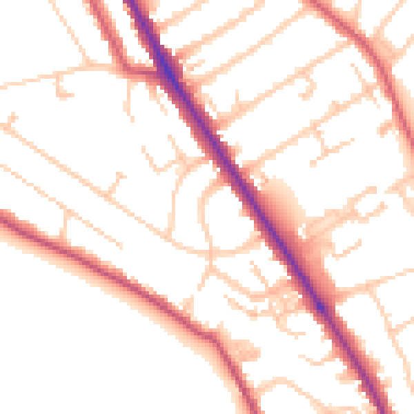
Daytime· 07:00 – 23:00
51.4dB

Everything within walking distance
Schools, transport stops and scenic spots near this property — 60 points of interest in total.
Beautiful places to visit nearby
Curated scenic spots within reach of this postcode, served by Beautifulplaces.ai. Photography and tagging come from their open dataset.
Common questions
The questions buyers, sellers and homeowners most often ask about 61 Bushy Park Road, Teddington, TW11 9DQ. Each answer is also embedded as structured data for search engines.