12 Tofts Close, Low Worsall, Yarm, TS15 9QA
About 12 Tofts Close
12 Tofts Close is a property in Low Worsall, Yarm, Yarm (TS15 9QA). It has council tax band E.
Energy performance
No EPC on record
This property doesn't have an Energy Performance Certificate yet. An EPC is required to sell or let — and unlocks our automated valuation.
Planning history
No planning applications are recorded against 12 Tofts Close, Low Worsall, Yarm, TS15 9QA. The full report also covers planning activity across the surrounding area.
Sales history & valuation
No sales recorded with HM Land Registry
That can mean the property has never traded since the registry began publishing in 1995, was a new build that hasn't been registered yet, or is held in the same hands long-term.
Median price across the last 5 sales in TS15 9QA: £535,000 (2024–2021).
Nearby sales in TS15 9QA
5 Tofts Close, Low Worsall, Yarm, TS15 9QA
Sold Dec 2024
£680,00014 Tofts Close, Low Worsall, Yarm, TS15 9QA
Sold Jul 2024
£483,50011 Tofts Close, Low Worsall, Yarm, TS15 9QA
Sold Oct 2023
£535,00019 Tofts Close, Low Worsall, Yarm, TS15 9QA
Sold Apr 2023
£600,0008 Tofts Close, Low Worsall, Yarm, TS15 9QA
Sold Dec 2021
£435,000
Similar properties nearby
1 Agricola Cottages, Hilton
TS15 9LA
1 Agricola Cottages, Low Worsall
TS15 9PL
1 Alder Road
TS15 9AG
1 Allerton View
TS15 9FH
1 Angrove Close
TS15 9RR
1 Ash Drive
TS15 9BZ
1 Ash Grove, Kirklevington
TS15 9NQ
1 Ashtree Terrace, Low Worsall
TS15 9PN
The neighbourhood at a glance
Daytime road noise here sits well below conversation level — a quiet pocket of the postcode.
Crime
3/mo
Steady year-on-year across the wider district.
Nearest stop
1.7 km
Rossmaith — bus stop.
Closest school
3.0 km
Layfield Primary School. 1 school nearby.
Road noise across the postcode
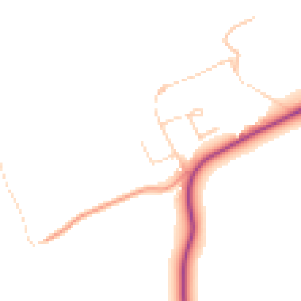
Daytime· 07:00 – 23:00
45.5dB

Night-time· 23:00 – 07:00
38.0dB