1 Hombersley Terrace, Holyhead Road, Ketley, Telford, TF1 5DL
About 1 Hombersley Terrace
1 Hombersley Terrace is a three-bedroom end-of-terrace house in Ketley, Telford, Telford (TF1 5DL). It has a recorded floor area of 97 m² (around 1044 sq ft), construction records dating it to before 1900 and council tax band A. The latest certificate (August 2015) shows an E (score 47), well below the UK norm with real room to improve. The recommended improvements would lift it to C (score 75), a 2-band jump. The latest certificate is from August 2015, so improvements made since then won't be reflected.
Across 1997–2021, sale prices on this property compounded at 5.3% per year. Today's modelled estimate of £168,000 is 24.4% above the 2021 sale price. Last sale on file: £135,000 in August 2021. That sale was during the post-pandemic price surge, when transactions cleared materially above pre-2020 trend.
Know exactly what you're buying at 1 Hombersley Terrace
Before you offer, see what the listing won't tell you, the true value, the red flags and the full history.
Valuation
against the asking price
Risks
planning & flood
Sold prices
similar homes nearby
Trends
the local market
What this property has
Inside
- Bedrooms3
- Bathrooms1
- Dining roomYes
Outside
- ParkingOff road
Building
- Heating systemGas
Energy performance
1 Hombersley Terrace's carbon output runs well above what efficient homes in the postcode produce.
EPC Expired
This certificate is over 10 years old and is no longer valid.Expired 12 Aug 2025
EPC Rating
Planning history
1 Hombersley Terrace has no planning applications on record.
The full report still covers planning activity across the surrounding area.
Sales history & valuation
Sale price has grown by over 3x since 1997.
£168,000
Modelled from EPC, postcode comparables and a sale-price growth of 5.3% per year over 24 years.
£135,000
Growth on file: 5.3% per year over 24 years.
Sales timeline
11 August 2021Most recent
£135,000
+16.4%over 5 years18 December 2015
£116,000
+193.7%over 18 years12 October 1997
£39,500
Median price across the last 2 sales in TF1 5DL: £98,000 (2013–2004).
Nearby sales in TF1 5DL
Everything we know about 1 Hombersley Terrace, in one report
What it's really worth, what could be wrong, and the planning, sales and area data in full.
- Am I paying too much?
- Is something wrong with it?
- Is the agent's story true?
- Will it hold its value?

Similar properties nearby
1 Church Street, Hadley
TF1 5RQ
1 Church View, Waterloo Road, Hadley Hollow
TF1 5NX
1 Broadway, Ketley
TF1 5AT
1 Far Vallens, Hadley
TF1 5SD
1 Beddall Way, Ketley
TF1 5FN
1 Bricklin Mews, Hadley
TF1 5LU
1 Bakers Lock, Hadley
TF1 5TE
1 Caldera Road, Hadley
TF1 5LT
The neighbourhood at a glance
Crime
5/mo
Steady year-on-year across the wider district.
Nearest stop
0.1 km
White Lion — bus stop.
Closest school
0.5 km
Meadows Primary School and Nursery. 21 schools nearby.
Go deeper on the local area
The full report breaks down crime, transport links, schools and air quality in depth.
Road noise across the postcode
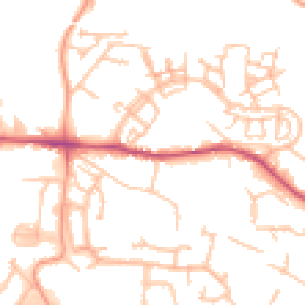
Daytime· 07:00 – 23:00
51.2dB

Night-time· 23:00 – 07:00
40.5dB