15 Arden Close, Shrewsbury, SY2 5YP
About 15 Arden Close
15 Arden Close is a four-bedroom detached house in Shrewsbury (SY2 5YP). It has a recorded floor area of 97 m² (around 1044 sq ft), construction records dating it to 1996-2002 and council tax band D. The latest certificate (August 2017) shows a C (score 73). The recommended improvements would push it to B (score 83).
Untraded for 27 years, with the last transfer in July 1999. Only one transfer is on record with HM Land Registry, suggesting it has stayed in the same hands for a long time. Today's modelled estimate of £356,000 sits 306.9% above the 1999 sale of £87,500. On a £-per-square-foot basis, the last sale (£84/sq ft) was about 54.6% below the postcode norm. Its energy rating outperforms most of the postcode (better than 75% of similar EPCs).
What this property has
Inside
- Bedrooms4
- Bathrooms2
Everything you need to know about 15 Arden Close
The true value, the hidden risks and the full sale history, in one report.
30-day money-back guarantee

The data behind every report


Energy performance
EPC Rating
Planning history
15 Arden Close has no planning applications on record.
Notable planning nearby
3applications of note in the surrounding area
We flagged 1 thing worth checking at 15 Arden Close
Independent checks surfaced things a buyer would want to understand before offering. The report explains each one in full, with the underlying data and what to ask.
- Larger development activity nearby
30-day money-back guarantee
Sales history & valuation
15 Arden Close's modelled value sits at over four times its earliest registered sale price (1999).
£356,000
Modelled from EPC, postcode comparables.
£87,500
Recorded with HM Land Registry.
Sales timeline
29 July 1999Most recent
£87,500
Median price across the last 5 sales in SY2 5YP: £229,000 (2019–2004).
Nearby sales in SY2 5YP
Versus other Arden Close homes
15 Arden Close outperforms the street on epc rating by a wide margin.
Price per m²
£902
Street avg £2,112
Floor Area
97 m²
Street avg 97 m²
Habitable Rooms
8 rooms
Street avg 7 rooms
CO₂ Emissions
3.0 t/year
Street avg 4.1 t/year
Everything you need to know about 15 Arden Close
The true value, the hidden risks and the full sale history, in one report.
30-day money-back guarantee
The data behind every report
Similar properties nearby
1 Burkitt Close
SY2 5WN
1 Burnham Avenue
SY2 5LL
1 Belgrave Place
SY2 5LJ
1 Abbots Place
SY2 5PY
1 Brighton Terrace, Bradford Street
SY2 5DS
1 Abbots Road
SY2 5PX
1 Allness Close
SY2 5XH
1 Alvaston Way
SY2 5TT
The neighbourhood at a glance
Crime
1/mo
Steady year-on-year across the wider district.
Nearest stop
1.4 km
Shrewsbury Rail Station — railway station.
Closest school
0.4 km
The Martin Wilson School. 17 schools nearby.
Go deeper on the local area
The full report breaks down crime, transport links, schools and air quality in depth.
Road noise across the postcode
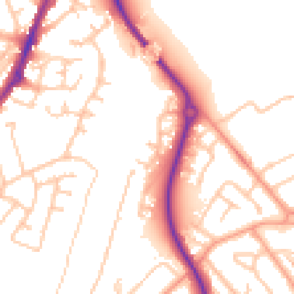
Daytime· 07:00 – 23:00
52.7dB

Night-time· 23:00 – 07:00
42.0dB