9 Coracle Close, Shrewsbury, SY1 4SQ
About 9 Coracle Close
9 Coracle Close is a three-bedroom semi-detached house in Shrewsbury (SY1 4SQ). It has a recorded floor area of 73 m² (around 786 sq ft). The latest certificate (July 2018) returns a B (score 83), comfortably above the UK average. The recommended improvements would push it to A (score 96). The property has solar panels on record, all of which lower running costs and tend to lift resale appeal. The home occupies a cul-de-sac position.
Most recent transfer was September 2025 at £250,000 — fresh data. Across 2018–2025, sale prices on this property compounded at 3.2% per year. On a £-per-square-foot basis, the last sale (£318/sq ft) was about 28% above the typical sold price in the postcode.
What this property has
Inside
- Bedrooms3
- Bathrooms1
- StudyYes
Outside
- Private gardenYes
- DrivewayYes
- Cul-de-sacYes
Building
- Heating systemGas
- Solar panelsYes
- RefurbishedYes
Everything you need to know about 9 Coracle Close
The true value, the hidden risks and the full sale history, in one report.
30-day money-back guarantee

The data behind every report


Energy performance
9 Coracle Close's carbon output is low for the local stock.
EPC Rating
Planning history
9 Coracle Close has no planning applications on record.
The full report still covers planning activity across the surrounding area.
Sales history & valuation
9 Coracle Close saw 3 transfers in just over a decade — high turnover for the postcode.
£247,000
Modelled from EPC, postcode comparables and a sale-price growth of 3.2% per year over 7 years.
£250,000
Growth on file: 3.2% per year over 7 years.
Sales timeline
18 September 2025Most recent
£250,000
+20.8%over 4 years24 September 2020
£207,000
+3.5%over 2 years2 August 2018
£199,950
Median price across the last 5 sales in SY1 4SQ: £233,000 (2023–2021).
Nearby sales in SY1 4SQ
Versus other Coracle Close homes
On years held, 9 Coracle Close runs well behind the street norm.
Price per m²
£3,425
Street avg £2,843
Floor Area
73 m²
Street avg 75 m²
CO₂ Emissions
1.2 t/year
Street avg 1.2 t/year
Years Held
1 years
Street avg 7 years
Everything you need to know about 9 Coracle Close
The true value, the hidden risks and the full sale history, in one report.
30-day money-back guarantee
The data behind every report
Similar properties nearby
The neighbourhood at a glance
Reported crime in the wider district is trending notably upward year-on-year.
Crime
10/mo
Rising year-on-year across the wider district.
Closest school
0.6 km
Harlescott Junior School. 14 schools nearby.
Go deeper on the local area
The full report breaks down crime, transport links, schools and air quality in depth.
Road noise across the postcode
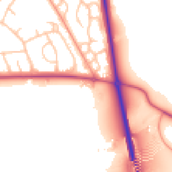
Daytime· 07:00 – 23:00
53.3dB
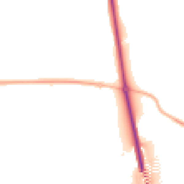
Night-time· 23:00 – 07:00
46.4dB