95 Carey Gardens, Wandsworth, London, SW8 4HJ
About 95 Carey Gardens
A plain-English summary derived from public records, EPC certificates, sold prices and local data.
95 Carey Gardens is a three-bedroom mid-terrace house in Wandsworth, London, London (SW8 4HJ). It has a recorded floor area of 85 m² (around 915 sq ft), construction records dating it to 1967-1975 and council tax band C. The latest certificate (May 2025) shows a C (score 79), near the top of the C band. When first surveyed in June 2015 the rating was D, the property has climbed 1 band since. Between certificates, roof efficiency went from Very Poor to Average and lighting went from Good to Very Good. Other recorded features include a balcony.
On a £-per-square-foot basis, the last sale (£486/sq ft) was about 89.5% above the typical sold price in the postcode. 11 years since the last transfer (July 2015).
What this property has
Pulled from EPC certificates, claim submissions and our property model. Empty categories are hidden — we only show what's known.
Inside
- Bedrooms3
- Open-plan layoutYes
- Dining roomYes
Outside
- Balcony
Energy performance
Every EPC certificate filed against this property — current rating, recorded improvements, and where there's headroom to reach a higher band.
Current Certificate(1 of 2)
May 2025
EPC Rating
A
B
C
C79
D
E
F
G
Main Heating
Gas
Main Fuel
Gas
Hot Water
Good
Windows
Good
CO2 Emissions
1.7 t/year
Occupancy
Rented
Planning history
Applications and permits filed against 95 Carey Gardens, Wandsworth, London, SW8 4HJ, sourced from the PlanIt planning register.
No planning applications are recorded against 95 Carey Gardens, Wandsworth, London, SW8 4HJ. The full report also covers planning activity across the surrounding area.
Full planning data for 95 Carey Gardens, Wandsworth, London, SW8 4HJ
Every application and decision on this property and nearby, in full, in the report.
Sales history & valuation
Recorded transactions, our model's current estimate, and a quick read on what neighbouring properties have sold for.
95 Carey Gardens valuation sits well clear of the typical sold price in this postcode.
Current estimate
See how we calculated this£477,000
Modelled from EPC, postcode comparables.
Last sold (2015)
£445,000
Recorded with HM Land Registry.
Sales timeline
Launch offer · 33% off
The complete analysis of 95 Carey Gardens, Wandsworth, London, SW8 4HJ
Everything we know about this property, compiled into one in-depth, downloadable report.
Detailed analysis
A written breakdown of everything that matters
Versus other Carey Gardens homes
Four headline reads against 37 similar flats on this street, drawn from the latest EPC and Land Registry data.
EPC Rating for 95 Carey Gardens runs comfortably ahead of the street norm.
Price per m²
£5,235
Street avg £3,317
Floor Area
85 m²
Street avg 81 m²
Habitable Rooms
4 rooms
Similar properties nearby
A handful of close matches in the same postcode area, ranked by likeness on bedrooms, type and floor area.
The neighbourhood at a glance
A condensed read of the local area. Each tile links through to the full breakdown on the London district page.
Rail-style transport is unusually close for this postcode.
Crime
12/mo
Rising year-on-year across the wider district.
Nearest stop
0.1 km
Clyston Street — bus stop.
Road noise across the postcode
Modelled day and night-time noise levels around SW8 4HJ from Defra's strategic mapping. The pin marks this postcode's centroid.
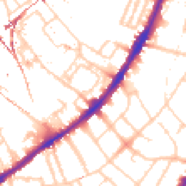
Daytime· 07:00 – 23:00
52.4dB

Everything within walking distance
Schools, transport stops and scenic spots near this property — 122 points of interest in total.
Common questions
The questions buyers, sellers and homeowners most often ask about 95 Carey Gardens, Wandsworth, London, SW8 4HJ. Each answer is also embedded as structured data for search engines.
