13 Cottingham Road, Lambeth, London, SW8 1LG
About 13 Cottingham Road
A plain-English summary derived from public records, EPC certificates, sold prices and local data.
13 Cottingham Road is a detached house in Lambeth, London, London (SW8 1LG). It has a recorded floor area of 46 m² (around 495 sq ft), construction records dating it to 1967-1975 and council tax band B. The latest certificate (November 2013) shows a D (score 62), on the cusp of jumping into the C band. Earlier certificates rated it C (October 2008); the latest reading is one band lower. Between certificates, wall efficiency went from Poor to Good and lighting went from Poor to Very Good; while window efficiency dropped from Good to Average and hot-water efficiency dropped from Good to Very Poor. The latest certificate is from November 2013, so improvements made since then won't be reflected. At 46 m² this is the 6th smallest of 72 units on EPC record in the building, where floor areas span 44–67 m². The building's EPC ratings span F to C across 72 units on file.
Energy performance
Every EPC certificate filed against this property — current rating, recorded improvements, and where there's headroom to reach a higher band.
13 Cottingham Road's EPC is over a decade old — improvements since won't be reflected.
EPC Expired
This certificate is over 10 years old and is no longer valid.Expired 14 Nov 2023
Planning history
Applications and permits filed against 13 Cottingham Road, Lambeth, London, SW8 1LG, sourced from the PlanIt planning register.
No planning applications are recorded against 13 Cottingham Road, Lambeth, London, SW8 1LG. The full report also covers planning activity across the surrounding area.
Full planning data for 13 Cottingham Road, Lambeth, London, SW8 1LG
Every application and decision on this property and nearby, in full, in the report.
Sales history & valuation
Recorded transactions, our model's current estimate, and a quick read on what neighbouring properties have sold for.
13 Cottingham Road has no Land Registry sales on file, suggesting it has stayed in the same hands since registration began.
Current estimate
See how we calculated this£374,000
Modelled from EPC, postcode comparables.
No sales recorded with HM Land Registry
That can mean the property has never traded since the registry began publishing in 1995, was a new build that hasn't been registered yet, or is held in the same hands long-term.
Launch offer · 33% off
The complete analysis of 13 Cottingham Road, Lambeth, London, SW8 1LG
Everything we know about this property, compiled into one in-depth, downloadable report.
Detailed analysis
A written breakdown of everything that matters
Versus other Cottingham Road homes
Three headline reads against 71 similar flats on this street, drawn from the latest EPC and Land Registry data.
13 Cottingham Road is notably below the street on co₂ emissions.
EPC Rating
62 (D)
Street avg 68 (D)
Floor Area
46 m²
Street avg 49 m²
CO₂ Emissions
3.1 t/year
Street avg 2.0 t/year
Similar properties nearby
A handful of close matches in the same postcode area, ranked by likeness on bedrooms, type and floor area.
The neighbourhood at a glance
A condensed read of the local area. Each tile links through to the full breakdown on the London district page.
Rail-style transport is unusually close for this postcode.
Crime
12/mo
Rising year-on-year across the wider district.
Nearest stop
0.2 km
Fentiman Road — bus stop.
Road noise across the postcode
Modelled day and night-time noise levels around SW8 1LG from Defra's strategic mapping. The pin marks this postcode's centroid.
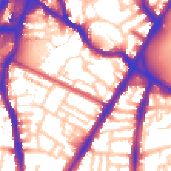
Daytime· 07:00 – 23:00
59.1dB

Everything within walking distance
Schools, transport stops and scenic spots near this property — 127 points of interest in total.
Common questions
The questions buyers, sellers and homeowners most often ask about 13 Cottingham Road, Lambeth, London, SW8 1LG. Each answer is also embedded as structured data for search engines.
