18 Clevedon Avenue, Stafford, ST17 0DJ
About 18 Clevedon Avenue
18 Clevedon Avenue is a four-bedroom detached house in Stafford (ST17 0DJ). It has a recorded floor area of 162 m² (around 1744 sq ft), construction records dating it to 1967-1975 and council tax band D. The property has solar panels on record, all of which lower running costs and tend to lift resale appeal. Records show the property has been extended at some point in its history. The home occupies a corner plot. The latest certificate (October 2015) shows a C (score 74). The recommended improvements would push it to B (score 83). The latest certificate is from October 2015, so improvements made since then won't be reflected.
At 162 m² the property is well over the postcode median (102 m² across 27 EPCs), placing it in the larger end of the local stock. Its energy rating outperforms most of the postcode (better than 85% of similar EPCs). On the market in November 2016 and unlisted since — roughly 10 years. 2 planning records sit against the property, 0 approved, 0 refused. Across 2005–2016, sale prices on this property compounded at 3.8% per year. Today's modelled estimate of £503,000 is 47.5% above the 2016 sale price.
What this property has
Inside
- Bedrooms4
- Bathrooms4
- Open-plan layoutYes
- EnsuiteYes
- StudyYes
Outside
- Private gardenSouth-facing
- GarageYes
- Corner plotYes
Building
- Solar panelsYes
- Previously extendedYes
Everything you need to know about 18 Clevedon Avenue
The true value, the hidden risks and the full sale history, in one report.
Pick your report · every report is £14.99
One time fee only - money back guarantee

The data behind every report


Energy performance
EPC Expired
This certificate is over 10 years old and is no longer valid.Expired 05 Oct 2025
EPC Rating
Get a survey for this property
Level 3 Building Survey
Because the property has been extended more than once, we believe a Level 3 building survey should be considered.
From £1,085 · Includes VAT
Planning history
Planning history includes recorded demolition works, indicating a major rebuild phase at this address.
2 applications on record at 18 Clevedon Avenue, Stafford, ST17 0DJ
- Nov 2005DemolitionFullOutcome in report
Extension: Part single, part two storey · Side and rear of property
Demolish existing GF extension, form 2 storey extension to side and single storey to rear, and alterations at front.
Extension- Documents
- 1 doc on file
- Reference
- 05/05264/FUL
- More recent applications — locked
- DemolitionFeb 2006Decision
Unlock 18 Clevedon Avenue, Stafford, ST17 0DJ's full planning history
You're seeing the shape of it. The report has the substance.
- Every decision — granted, refused or withdrawn (2 on record)
- All 2 applications on this property in full, plus 1 notable nearby
- The 2 documents, officer reports & conditions
- What the pattern means for extending or converting here
One time fee only - money back guarantee
Sales history & valuation
18 Clevedon Avenue valuation sits well clear of the typical sold price in this postcode.
£503,000
Modelled from EPC, postcode comparables and a sale-price growth of 3.8% per year over 11 years.
£341,000
Growth on file: 3.8% per year over 11 years.
Sales timeline
17 November 2016Most recent
£341,000
+53.3%over 11 years20 June 2005
£222,500
Median price across the last 5 sales in ST17 0DJ: £340,000 (2025–2023).
Nearby sales in ST17 0DJ
Versus other Clevedon Avenue homes
On epc rating, 18 Clevedon Avenue stands well clear of the street.
Price per m²
£2,105
Street avg £2,550
Floor Area
162 m²
Street avg 105 m²
Habitable Rooms
7 rooms
Street avg 5 rooms
CO₂ Emissions
4.5 t/year
Street avg 4.8 t/year
Everything you need to know about 18 Clevedon Avenue
The true value, the hidden risks and the full sale history, in one report.
Pick your report · every report is £14.99
One time fee only - money back guarantee
The data behind every report
Similar properties nearby
1 Alsop Crest, Acton Trussell
ST17 0SJ
1 Briar Close
ST17 0NG
1 Bank Top Cottage, Top Road, Acton Trussell
ST17 0RQ
1 Belvedere Close
ST17 0AL
1 Ascot Road
ST17 0AG
1 Baswich Crest
ST17 0HL
1 Beechfield Drive
ST17 0YH
1 Anson Drive
ST17 0LT
The neighbourhood at a glance
Crime
3/mo
Steady year-on-year across the wider district.
Nearest stop
0.1 km
The Rise — bus stop.
Closest school
0.3 km
Walton High School. 15 schools nearby.
Go deeper on the local area
A Local Area report breaks down crime, transport links, schools and air quality in depth.
Road noise across the postcode
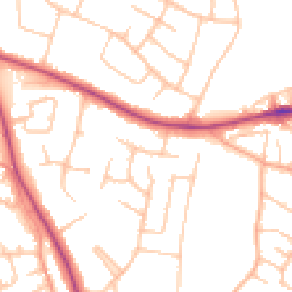
Daytime· 07:00 – 23:00
50.5dB

Night-time· 23:00 – 07:00
41.0dB