Astons, Flat 4, Browning Street, Stafford, ST16 3AX
About Astons
Astons is a one-bedroom mid-terrace house in Stafford (ST16 3AX). It has a recorded floor area of 46 m² (around 495 sq ft), construction records dating it to 1900-1929 and council tax band A. At 46 m² this is the largest unit on EPC record across Astons (36–46 m²). On EPC score it ranks last in the building (74 versus a best of 76). The property has solar panels on record, all of which lower running costs and tend to lift resale appeal. The latest certificate (October 2020) shows a C (score 74).
At 46 m² it sits well below the postcode median (87 m² across 9 EPCs), making it one of the more compact homes locally. Across 2011–2022, sale prices on this property compounded at 0.9% per year. Today's modelled estimate of £107,000 is 25.9% above the 2022 sale price. Sold November 2022 for £85,000. That sale was during the post-pandemic price surge, when transactions cleared materially above pre-2020 trend.
What this property has
Inside
- Bedrooms1
- Open-plan layoutYes
Building
- Solar panelsYes
- RefurbishedYes
Everything you need to know about Astons
The true value, the hidden risks and the full sale history, in one report.
Pick your report · every report is £14.99
One time fee only - money back guarantee

The data behind every report


Energy performance
EPC Rating
Get a survey for this property
Level 3 Building Survey
Because the property was built before 1919 and has solid (non-cavity) walls, we believe a Level 3 building survey should be considered.
From £820 · Includes VAT
Planning history
Astons has no planning applications on record.
But the area is active
8 notable applications nearby — larger schemes and conversions that could reshape the street. The report maps them all.
Sales history & valuation
Astons's sale-price growth has lagged the wider UK trajectory across its history on file.
£107,000
Modelled from EPC, postcode comparables and a sale-price growth of 0.9% per year over 11 years.
£85,000
Growth on file: 0.9% per year over 11 years.
Sales timeline
11 November 2022Most recent
£85,000
+10.4%over 11 years25 May 2011
£77,000
Median price across the last 5 sales in ST16 3AX: £85,000 (2025–2023).
Nearby sales in ST16 3AX
Astons, Flat 5, Browning Street, Stafford, ST16 3AX
Sold Jan 2025
£85,00017 Browning Street, Stafford, ST16 3AX
Sold Nov 2024
£10,00019 Browning Street, Stafford, ST16 3AX
Sold Nov 2024
£150,00018 Browning Street, Stafford, ST16 3AX
Sold Nov 2024
£170,000Astons, Flat 2, Browning Street, Stafford, ST16 3AX
Sold Dec 2023
£80,000
Versus other Browning Street homes
On price per m², Astons runs well behind the street norm.
Price per m²
£1,848
Street avg £2,205
Floor Area
46 m²
Street avg 63 m²
Habitable Rooms
2 rooms
Street avg 4 rooms
CO₂ Emissions
1.6 t/year
Street avg 3.2 t/year
Everything you need to know about Astons
The true value, the hidden risks and the full sale history, in one report.
Pick your report · every report is £14.99
One time fee only - money back guarantee
The data behind every report
Similar properties nearby
Astons, Flat 3, Browning Street
ST16 3AX
Astons, Flat 6, Browning Street
ST16 3AX
Astons, Flat 5, Browning Street
ST16 3AX
Astons, Flat 1, Browning Street
ST16 3AX
Astons, Flat 2, Browning Street
ST16 3AX
Coniston House, Flat 15, Corporation Street
ST16 3LP
Coniston House, Flat 11, Corporation Street
ST16 3LP
Coniston House, Flat 10, Corporation Street
ST16 3LP
The neighbourhood at a glance
Crime
7/mo
Steady year-on-year across the wider district.
Nearest stop
0.1 km
Marston Road — bus stop.
Closest school
0.3 km
St Patrick's Catholic Primary School. 21 schools nearby.
Go deeper on the local area
A Local Area report breaks down crime, transport links, schools and air quality in depth.
Road noise across the postcode
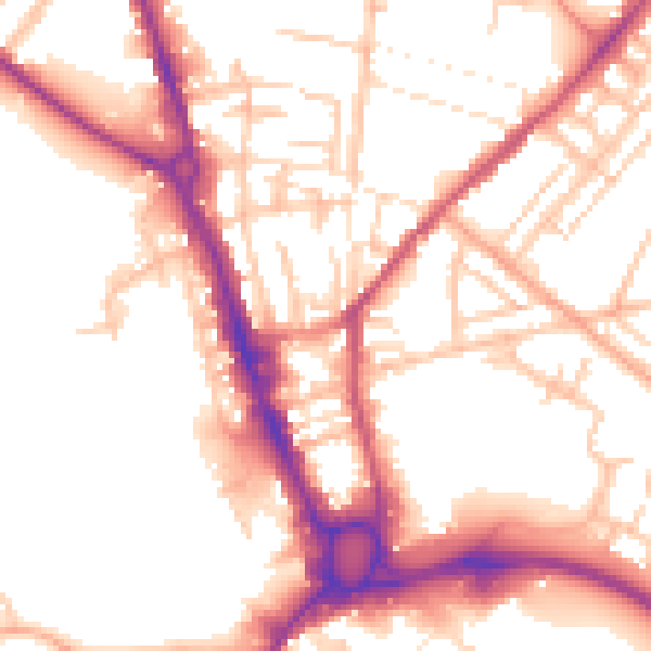
Daytime· 07:00 – 23:00
54.4dB

Night-time· 23:00 – 07:00
44.7dB