1 Ewing Gardens, Langdon Hills, Basildon, SS16 5PY
About 1 Ewing Gardens
1 Ewing Gardens is a detached house in Langdon Hills, Basildon, Basildon (SS16 5PY). It has a recorded floor area of 112 m² (around 1206 sq ft) and construction records dating it to 2021. The latest certificate (January 2022) returns a B (score 84), comfortably above the UK average. The recommended improvements would push it to A (score 94).
Last sale on file: £519,995 in February 2022. That sale was during the post-pandemic price surge, when transactions cleared materially above pre-2020 trend.
Everything you need to know about 1 Ewing Gardens
The true value, the hidden risks and the full sale history, in one report.
Pick your report · every report is £14.99
One time fee only - money back guarantee

The data behind every report


Energy performance
EPC Rating
Get a survey for this property
Level 2 HomeBuyer Report
We've checked 10 risk factors against the available data for this property and believe a Level 2 HomeBuyer Report could be a suitable option for you.
From £795 · Includes VAT
Planning history
1 Ewing Gardens has no planning applications on record.
But the area is active
7 notable applications nearby — larger schemes and conversions that could reshape the street. The report maps them all.
Sales history & valuation
Latest sale on 1 Ewing Gardens was the highest on Land Registry record across the postcode.
£543,000
Modelled from EPC, postcode comparables.
£519,995
Recorded with HM Land Registry.
Sales timeline
25 February 2022Most recent
£519,995
Median price across the last 5 sales in SS16 5PY: £449,995 (2022–2022).
Nearby sales in SS16 5PY
19 Ewing Gardens, Langdon Hills, Basildon, SS16 5PY
Sold Mar 2022
£434,99517 Ewing Gardens, Langdon Hills, Basildon, SS16 5PY
Sold Mar 2022
£449,99515 Ewing Gardens, Langdon Hills, Basildon, SS16 5PY
Sold Mar 2022
£459,9957 Ewing Gardens, Langdon Hills, Basildon, SS16 5PY
Sold Mar 2022
£459,99511 Ewing Gardens, Langdon Hills, Basildon, SS16 5PY
Sold Mar 2022
£446,995
Versus other Ewing Gardens homes
On co₂ emissions, 1 Ewing Gardens runs well behind the street norm.
Price per m²
£4,643
Street avg £4,440
Floor Area
112 m²
Street avg 102 m²
CO₂ Emissions
1.6 t/year
Street avg 1.3 t/year
Years Held
4 years
Street avg 4 years
Everything you need to know about 1 Ewing Gardens
The true value, the hidden risks and the full sale history, in one report.
Pick your report · every report is £14.99
One time fee only - money back guarantee
The data behind every report
Similar properties nearby
1 Falcon Way
SS16 5JA
1 Dixon Mews, Langdon Hills
SS16 5NU
1 Bebington Link, Langdon Hills
SS16 5LE
1 Clayton Way, Langdon Hills
SS16 5PN
1 Bebington Drive, Langdon Hills
SS16 5JZ
1 Curlew Crescent
SS16 5HR
1 Clark Street
SS16 5NW
1 Dixon Road, Langdon Hills
SS16 5JW
The neighbourhood at a glance
Rail-style transport is unusually close for this postcode.
Crime
10/mo
Falling year-on-year across the wider district.
Nearest stop
0.3 km
Castlemayne — bus stop.
Closest school
0.2 km
Chapel Hill Primary School & Nursery. 23 schools nearby.
Go deeper on the local area
A Local Area report breaks down crime, transport links, schools and air quality in depth.
Road noise across the postcode
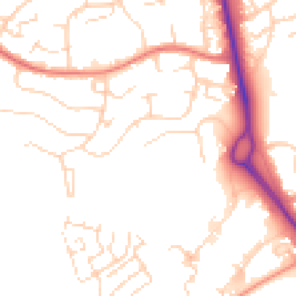
Daytime· 07:00 – 23:00
50.3dB
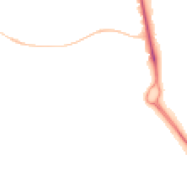
Night-time· 23:00 – 07:00
40.9dB