Skip to content

47a, Wyndham Road, Salisbury, SP1 3AB

3 sales on record
Property type
Semi-detached
Floor Ground
Habitable rooms
3
From EPC
Floor area
73 m²
786 sq ft
Energy rating
D
Score 66
Council tax
Band B
Tenure
Private Rental
Overview

About 47a

A plain-English summary derived from public records, EPC certificates, sold prices and local data.

47a is a semi-detached house in Salisbury (SP1 3AB). It has a recorded floor area of 73 m² (around 786 sq ft), construction records dating it to 1900-1929 and council tax band B. The latest certificate (August 2019) shows a D (score 66), on the cusp of jumping into the C band. The rating has held steady at D across 5 certificates since May 2009. Between certificates, wall efficiency went from Very Poor to Poor and lighting went from Good to Very Good; while main heating dropped from Very Good to Good. The recommended improvements would push it to C (score 75). At 73 m² this is the 16th smallest of 47 units on EPC record in the building, where floor areas span 28–355 m². The building's EPC ratings span F to C across 47 units on file.

Held since September 2001 — that's 25 years off the open market, well above the local norm. Across 1996–2001, sale prices on this property compounded at 27% per year. Today's modelled estimate of £192,000 sits 140% above the 2001 sale of £80,000. On a £-per-square-foot basis, the last sale (£102/sq ft) was about 59.7% below the postcode norm. At 73 m² it sits well below the postcode median (107 m² across 46 EPCs), making it one of the more compact homes locally.

Before you decide

Everything you need to know about 47a

The true value, the hidden risks and the full sale history, in one report.

Larger development activity nearby

Pick your report · every report is £14.99

One time fee only - money back guarantee

Preview of the full property report

The data behind every report

  • HM Land Registry, source of sold price history
  • Department for Education, source of schools data
  • Police.uk, source of crime statistics
  • Department for Transport, source of stations and transport links
  • Environment Agency, source of flood risk data
  • Department for Environment, Food & Rural Affairs, source of road noise data
  • PlanIt, source of planning application records
Energy

Energy performance

Every EPC certificate filed against this property — current rating, recorded improvements, and where there's headroom to reach a higher band.
Current Certificate(1 of 5)
Aug 2019

EPC Rating

A
B
C
D
D66
E
F
G
Main Heating
Gas
Main Fuel
Gas
Hot Water
Good
Windows
Very Poor
CO2 Emissions
2.6 t/year
Occupancy
Rented

Property Improvements

Changes detected from historical EPC data

Mar 2010from May 2009
EPC improved fromD60toB82
Hot Water
GoodVery Good

Hot water efficiency improved

Windows
SingleFull Double

Single glazing replaced with double or better glazing

Wall Insulation
Uninsulated SolidInsulated Cavity

Cavity wall insulation installed

Floor Insulation
UninsulatedInsulated

Floor insulation added or improved

Low Energy Lighting
57%3%

Low energy lighting percentage decreased

Apr 2012from Mar 2010
EPC improved fromB82toD61
Heating Controls
FullProg + Stat

Heating controls changed

Hot Water
Very GoodGood

Hot water efficiency decreased

Jun 2016from Apr 2012
EPC improved fromD61toC74
Heating Controls
Prog + StatFull

Heating controls upgraded for better temperature management

Windows
SingleFull Double

Single glazing replaced with double or better glazing

Wall Insulation
UninsulatedInsulated Cavity

Cavity wall insulation installed

Roof Insulation
PartialWell Insulated

Loft insulation upgraded to recommended levels

Low Energy Lighting
0%75%

More low energy lighting installed

Aug 2019from Jun 2016
EPC improved fromC74toD66
Low Energy Lighting
75%100%

More low energy lighting installed

SDL Surveying

Get a survey for this property

Level 3 Building Survey

Victorian-eraGround Floor FlatEPC DPre-1919 build

Because the property was built before 1919, we believe a Level 3 building survey should be considered.

From £820 · Includes VAT

Planning

Planning history

Applications and permits filed against 47a, Wyndham Road, Salisbury, SP1 3AB, sourced from the PlanIt planning register.

47a has no planning applications on record.

2

But the area is active

2 notable applications nearby — larger schemes and conversions that could reshape the street. The report maps them all.

Price

Sales history & valuation

Recorded transactions, our model's current estimate, and a quick read on what neighbouring properties have sold for.

Sale price has grown by over 3x since 1996.

Current estimate

£192,000

Modelled from EPC, postcode comparables and a sale-price growth of 27.0% per year over 6 years.

See how we calculated this
Last sold (2001)

£80,000

Growth on file: 27.0% per year over 6 years.

Sales timeline

  1. 19 September 2001Most recent

    £80,000

    +116.5%over 5 years
  2. 19 June 1996

    £36,950

    +79.4%
  3. 17 January 1996

    £20,600

Median price across the last 5 sales in SP1 3AB: £630,000 (2025–2023).

On the street

Versus other Wyndham Road homes

Four headline reads against 22 similar flats on this street, drawn from the latest EPC and Land Registry data.

On price per m², 47a runs well behind the street norm.

Price per m²

£1,096

Street avg £3,871

Strongly below

Floor Area

73 m²

Street avg 66 m²

Above

Habitable Rooms

3 rooms

Street avg 3 rooms

Above

CO₂ Emissions

2.6 t/year

Street avg 3.9 t/year

Above
Before you decide

Everything you need to know about 47a

The true value, the hidden risks and the full sale history, in one report.

Larger development activity nearby

Pick your report · every report is £14.99

One time fee only - money back guarantee

Preview of the full property report

The data behind every report

  • HM Land Registry, source of sold price history
  • Department for Education, source of schools data
  • Police.uk, source of crime statistics
  • Department for Transport, source of stations and transport links
  • Environment Agency, source of flood risk data
  • Department for Environment, Food & Rural Affairs, source of road noise data
  • PlanIt, source of planning application records
Area

The neighbourhood at a glance

A condensed read of the local area. Each tile links through to the full breakdown on the Salisbury district page.

Crime

4/mo

Steady year-on-year across the wider district.

Nearest stop

0.2 km

Wyndham Road — bus stop.

Closest school

0.7 km

South Wilts Grammar School. 20 schools nearby.

Go deeper on the local area

A Local Area report breaks down crime, transport links, schools and air quality in depth.

Noise

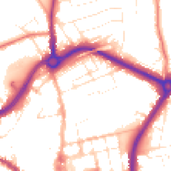
Road noise across the postcode

Modelled day and night-time noise levels around SP1 3AB from Defra's strategic mapping. The pin marks this postcode's centroid.
Daytime road noise heatmap for SP1 3AB

Daytime· 07:00 – 23:00

53.0dB

Low
Night-time road noise heatmap for SP1 3AB

Night-time· 23:00 – 07:00

43.4dB

Low
55 dB
60 dB
65 dB
70 dB
75 dB
80 dB
Defra Road Noise Strategic Mapping, Round 4
FAQ

Common questions

The questions buyers, sellers and homeowners most often ask about 47a, Wyndham Road, Salisbury, SP1 3AB. Each answer is also embedded as structured data for search engines.