10 Mersham Gardens, Southampton, SO18 6TF
About 10 Mersham Gardens
10 Mersham Gardens is a two-bedroom detached house in Southampton (SO18 6TF). It has a recorded floor area of 73 m² (around 786 sq ft), construction records dating it to 1950-1966 and council tax band C. The latest certificate (July 2018) shows a D (score 61), on the cusp of jumping into the C band. The recommended improvements would push it to C (score 80).
Today's modelled estimate of £322,000 is 22.9% above the 2018 sale price. On a £-per-square-foot basis, the last sale (£333/sq ft) was about 33.1% above the typical sold price in the postcode. Most recent transfer: August 2018 at £262,000.
What this property has
Inside
- Bedrooms2
- Bathrooms1
- Dining roomYes
- CloakroomYes
Outside
- Private gardenFront and rear
- GarageYes
Building
- Heating systemGas
Everything you need to know about 10 Mersham Gardens
The true value, the hidden risks and the full sale history, in one report.
30-day money-back guarantee

The data behind every report


Energy performance
EPC Rating
Planning history
10 Mersham Gardens has no planning applications on record.
Notable planning nearby
1applications of note in the surrounding area
Sales history & valuation
10 Mersham Gardens valuation sits well clear of the typical sold price in this postcode.
£322,000
Modelled from EPC, postcode comparables.
£262,000
Recorded with HM Land Registry.
Sales timeline
2 August 2018Most recent
£262,000
Median price across the last 5 sales in SO18 6TF: £320,000 (2025–2021).
Nearby sales in SO18 6TF
17 Mersham Gardens, Southampton, SO18 6TF
Sold Feb 2025
£320,00029 Mersham Gardens, Southampton, SO18 6TF
Sold Apr 2024
£320,00027 Mersham Gardens, Southampton, SO18 6TF
Sold Sept 2021
£254,00020 Mersham Gardens, Southampton, SO18 6TF
Sold Sept 2021
£325,00019 Mersham Gardens, Southampton, SO18 6TF
Sold Aug 2021
£400,000
Versus other Mersham Gardens homes
On co₂ emissions, 10 Mersham Gardens stands well clear of the street.
Price per m²
£3,589
Street avg £3,346
Floor Area
73 m²
Street avg 85 m²
Habitable Rooms
4 rooms
Street avg 4 rooms
CO₂ Emissions
3.1 t/year
Street avg 4.0 t/year
Everything you need to know about 10 Mersham Gardens
The true value, the hidden risks and the full sale history, in one report.
30-day money-back guarantee
The data behind every report
Similar properties nearby
1 Mersham Gardens
SO18 6TF
1 Jubilee Gardens
SO18 6LX
10 Rutland Court, Balaclava Road
SO18 6RX
1 Almatade Road
SO18 6AA
1 Yew Road
SO18 6AW
10 Brook Road
SO18 6BA
1 Rutland Court, Balaclava Road
SO18 6RX
10 Almatade Road
SO18 6AB
The neighbourhood at a glance
Reported crime in the wider district is trending notably upward year-on-year.
Crime
6/mo
Rising year-on-year across the wider district.
Nearest stop
0.1 km
Chichester Road — bus stop.
Closest school
0.1 km
Glenfield Infant School. 35 schools nearby.
Go deeper on the local area
The full report breaks down crime, transport links, schools and air quality in depth.
Road noise across the postcode
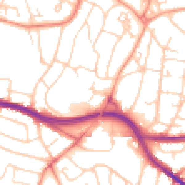
Daytime· 07:00 – 23:00
52.9dB

Night-time· 23:00 – 07:00
42.2dB