Vespasian Quay 37a, Flat 3, Vespasian Road, Southampton, SO18 1EB
About Vespasian Quay 37a
Vespasian Quay 37a is a mid-terrace house in Southampton (SO18 1EB). It has a recorded floor area of 107 m² (around 1152 sq ft) and construction records dating it to 1996-2002. At 107 m² this is the largest unit on EPC record across Vespasian Quay 37a (55–107 m²). The building's EPC ratings span D to B across 8 units on file. The latest certificate (October 2019) shows a C (score 77), near the top of the C band. The rating has held steady at C across 2 certificates since October 2008. Between certificates, window efficiency went from Average to Good, lighting went from Good to Very Good and main heating went from Poor to Average. Main heating runs on electricity.
At 107 m² the property is well over the postcode median (73 m² across 7 EPCs), placing it in the larger end of the local stock.
Everything you need to know about Vespasian Quay 37a
The true value, the hidden risks and the full sale history, in one report.
30-day money-back guarantee

The data behind every report


Energy performance
EPC Rating
Property Improvements
Changes detected from historical EPC data
Window efficiency improved
More low energy lighting installed
Planning history
Vespasian Quay 37a has no planning applications on record.
Notable planning nearby
5applications of note in the surrounding area
We flagged 2 things worth checking at Vespasian Quay 37a
Independent checks surfaced things a buyer would want to understand before offering. The report explains each one in full, with the underlying data and what to ask.
- Signs of HMO activity in the area
- Environmental risk flagged
30-day money-back guarantee
Sales history & valuation
Vespasian Quay 37a has no Land Registry sales on file, suggesting it has stayed in the same hands since registration began.
£275,000
Modelled from EPC, postcode comparables.
No sales recorded with HM Land Registry
That can mean the property has never traded since the registry began publishing in 1995, was a new build that hasn't been registered yet, or is held in the same hands long-term.
Versus other Vespasian Road homes
Floor Area for Vespasian Quay 37a runs comfortably ahead of the street norm.
EPC Rating
77 (C)
Street avg 76 (C)
Floor Area
107 m²
Street avg 71 m²
CO₂ Emissions
3.6 t/year
Street avg 2.5 t/year
Habitable Rooms
3 rooms
Street avg 3 rooms
Everything you need to know about Vespasian Quay 37a
The true value, the hidden risks and the full sale history, in one report.
30-day money-back guarantee
The data behind every report
Similar properties nearby
22a, Flat 4, Harcourt Road
SO18 1GP
127 129, Flat 1, Newton Road
SO18 1NH
3 5, Flat 16, Cobbett Road
SO18 1HJ
22a, Flat 2, Harcourt Road
SO18 1GP
3 5, Flat 17, Cobbett Road
SO18 1HJ
22a, Flat 1, Harcourt Road
SO18 1GP
22a, Flat 3, Harcourt Road
SO18 1GP
3 5, Flat 21, Cobbett Road
SO18 1HJ
The neighbourhood at a glance
Rail-style transport is unusually close for this postcode.
Crime
6/mo
Rising year-on-year across the wider district.
Nearest stop
0.2 km
Rampart Road — bus stop.
Closest school
0.4 km
Bitterne Manor Primary School. 40 schools nearby.
Go deeper on the local area
The full report breaks down crime, transport links, schools and air quality in depth.
Road noise across the postcode
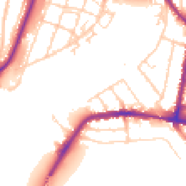
Daytime· 07:00 – 23:00
52.0dB

Night-time· 23:00 – 07:00
43.8dB