1 Anton Crescent, Sutton, SM1 2NT
About 1 Anton Crescent
1 Anton Crescent is an end-of-terrace house in Sutton (SM1 2NT). It has a recorded floor area of 92 m² (around 990 sq ft) and council tax band D. The latest certificate (April 2014) returns a high B (score 91), putting the home a stone's throw from an A rating. The recommended improvements would push it to A (score 92). The latest certificate is from April 2014, so improvements made since then won't be reflected.
Everything you need to know about 1 Anton Crescent
The true value, the hidden risks and the full sale history, in one report.
30-day money-back guarantee

The data behind every report


Energy performance
1 Anton Crescent's carbon output is low for the local stock.
EPC Expired
This certificate is over 10 years old and is no longer valid.Expired 07 Apr 2024
EPC Rating
Planning history
1 Anton Crescent has no planning applications on record.
Notable planning nearby
12applications of note in the surrounding area
We flagged 2 things worth checking at 1 Anton Crescent
Independent checks surfaced things a buyer would want to understand before offering. The report explains each one in full, with the underlying data and what to ask.
- Signs of HMO activity in the area
- Larger development activity nearby
30-day money-back guarantee
Sales history & valuation
1 Anton Crescent has no Land Registry sales on file, suggesting it has stayed in the same hands since registration began.
£439,000
Modelled from EPC, postcode comparables.
No sales recorded with HM Land Registry
That can mean the property has never traded since the registry began publishing in 1995, was a new build that hasn't been registered yet, or is held in the same hands long-term.
Versus other Anton Crescent homes
On co₂ emissions, 1 Anton Crescent runs well behind the street norm.
EPC Rating
91 (B)
Street avg 91 (B)
Floor Area
92 m²
Street avg 93 m²
CO₂ Emissions
0.7 t/year
Street avg 0.6 t/year
Everything you need to know about 1 Anton Crescent
The true value, the hidden risks and the full sale history, in one report.
30-day money-back guarantee
The data behind every report
Similar properties nearby
1 Elmbrook Road, Cheam
SM1 2JF
1 Bourne Way, Cheam
SM1 2EN
1 Ashton Close
SM1 2HJ
1 Alma Crescent, Cheam
SM1 2LN
1 Alberta Avenue, Cheam
SM1 2LF
1 Dibdin Close
SM1 2PJ
1 Albany Mews, Camden Road
SM1 2RE
1 Cormorant Place, Cheam
SM1 2XD
The neighbourhood at a glance
Rail-style transport is unusually close for this postcode.
Crime
9/mo
Rising year-on-year across the wider district.
Nearest stop
0.1 km
Collingwood Road / Oldfields Road — bus stop.
Closest school
0.1 km
Westbourne Primary School. 47 schools nearby.
Go deeper on the local area
The full report breaks down crime, transport links, schools and air quality in depth.
Road noise across the postcode
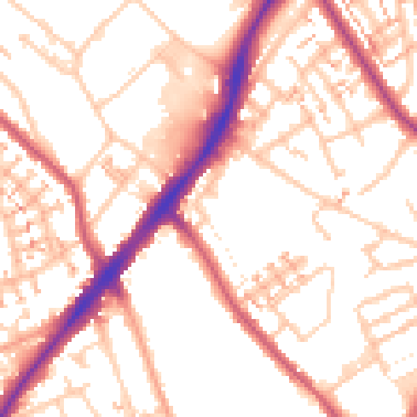
Daytime· 07:00 – 23:00
54.0dB

Night-time· 23:00 – 07:00
43.3dB