1 Bread Street, Macclesfield, SK11 8EY
About 1 Bread Street
1 Bread Street is a two-bedroom end-of-terrace house in Macclesfield (SK11 8EY). It has a recorded floor area of 55 m² (around 592 sq ft), construction records dating it to before 1900 and council tax band B. The latest certificate (December 2014) shows a D (score 61), on the cusp of jumping into the C band. The recommended improvements would lift it to B (score 87), a 2-band jump. The latest certificate is from December 2014, so improvements made since then won't be reflected.
Last sale on file: £130,000 in August 2019. Across the public record there are 5 sales, relatively high churn for a single property. Across 1996–2019, sale prices on this property compounded at 5.3% per year. Today's modelled estimate of £190,000 is 46.2% above the 2019 sale price. On a £-per-square-foot basis, the last sale (£220/sq ft) was about 45.5% above the typical sold price in the postcode.
What this property has
Inside
- Bedrooms2
- Bathrooms1
Everything you need to know about 1 Bread Street
The true value, the hidden risks and the full sale history, in one report.
30-day money-back guarantee

The data behind every report


Energy performance
Recommended upgrades on file would lift this property by multiple EPC bands.
EPC Expired
This certificate is over 10 years old and is no longer valid.Expired 13 Dec 2024
EPC Rating
Planning history
1 Bread Street has no planning applications on record.
Notable planning nearby
3applications of note in the surrounding area
Sales history & valuation
Sale price has grown by over 3x since 1996.
£190,000
Modelled from EPC, postcode comparables and a sale-price growth of 5.3% per year over 23 years.
£130,000
Growth on file: 5.3% per year over 23 years.
Sales timeline
8 August 2019Most recent
£130,000
+23.8%over 3 years30 November 2015
£105,000
-10.6%over 10 years30 August 2005
£117,500
+164.0%over 6 years22 July 1999
£44,500
+9.9%over 2 years29 November 1996
£40,500
Median price across the last 5 sales in SK11 8EY: £89,950 (2024–2014).
Nearby sales in SK11 8EY
Versus other Bread Street homes
1 Bread Street is notably below the street on epc rating.
Price per m²
£2,364
Street avg £2,519
Floor Area
55 m²
Street avg 52 m²
Habitable Rooms
3 rooms
Street avg 3 rooms
CO₂ Emissions
3.3 t/year
Street avg 2.6 t/year
Everything you need to know about 1 Bread Street
The true value, the hidden risks and the full sale history, in one report.
30-day money-back guarantee
The data behind every report
Similar properties nearby
The neighbourhood at a glance
Crime
6/mo
Steady year-on-year across the wider district.
Nearest stop
0.2 km
Park Lane — bus stop.
Closest school
0.4 km
Parkroyal Community School. 19 schools nearby.
Go deeper on the local area
The full report breaks down crime, transport links, schools and air quality in depth.
Road noise across the postcode
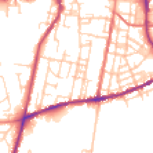
Daytime· 07:00 – 23:00
51.2dB

Night-time· 23:00 – 07:00
41.8dB