15 Pennethorne Road, Southwark, London, SE15 5TH
About 15 Pennethorne Road
15 Pennethorne Road is a property in Southwark, London, London (SE15 5TH). It has council tax band D.
Energy performance
No EPC on record
This property doesn't have an Energy Performance Certificate yet. An EPC is required to sell or let — and unlocks our automated valuation.
Planning history
No planning applications are recorded against 15 Pennethorne Road, Southwark, London, SE15 5TH. The full report also covers planning activity across the surrounding area.
Sales history & valuation
No sales recorded with HM Land Registry
That can mean the property has never traded since the registry began publishing in 1995, was a new build that hasn't been registered yet, or is held in the same hands long-term.
Median price across the last 5 sales in SE15 5TH: £385,000 (2025–2019).
Nearby sales in SE15 5TH
17b, Pennethorne Road, Southwark, London, SE15 5TH
Sold Jan 2025
£340,0007a, Pennethorne Road, Southwark, London, SE15 5TH
Sold Sept 2021
£27,5005a, Pennethorne Road, Southwark, London, SE15 5TH
Sold Apr 2021
£385,0001a, Pennethorne Road, Southwark, London, SE15 5TH
Sold Feb 2021
£725,00033 Pennethorne Road, Southwark, London, SE15 5TH
Sold Feb 2019
£595,000
Similar properties nearby
1 2 Central Buildings, Flat A, Rye Lane, Southwark
SE15 5DW
1 2 Central Buildings, Flat B, Rye Lane, Southwark
SE15 5DW
1 2 Central Buildings, Flat C, Rye Lane, Southwark
SE15 5DW
1 2 Central Buildings, Flat D, Rye Lane, Southwark
SE15 5DW
1 Abid Mews, Southwark
SE15 5BJ
1 Ainsworth Close, Southwark
SE15 5AX
1 Ashmore Close, Southwark
SE15 5GY
1 Azenby Road, Southwark
SE15 5AJ
The neighbourhood at a glance
Rail-style transport is unusually close for this postcode.
Crime
11/mo
Rising year-on-year across the wider district.
Nearest stop
0.3 km
Carlton Grove — bus stop.
Closest school
0.1 km
Harris Primary Academy Peckham Park. 92 schools nearby.
Road noise across the postcode
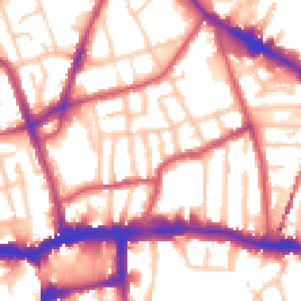
Daytime· 07:00 – 23:00
56.5dB
Night-time· 23:00 – 07:00
46.1dB