12 Bramwell Close, Sheffield, S3 7PG
About 12 Bramwell Close
12 Bramwell Close is a three-bedroom semi-detached house in Sheffield (S3 7PG). It has a recorded floor area of 92 m² (around 990 sq ft), construction records dating it to 1996-2002 and council tax band B. Other recorded features include a conservatory. The latest certificate (January 2020) shows a C (score 72). The recommended improvements would push it to B (score 83).
Untraded for 23 years, with the last transfer in November 2003. At 92 m² the property is well over the postcode median (60 m² across 10 EPCs), placing it in the larger end of the local stock. Today's modelled estimate of £250,000 sits 117.4% above the 2003 sale of £115,000.
What this property has
Inside
- Bedrooms3
- Bathrooms3
- Dining roomYes
- CloakroomYes
- EnsuiteYes
- StudyYes
- ConservatoryYes
Outside
- Private gardenRear
- DrivewayYes
Everything you need to know about 12 Bramwell Close
The true value, the hidden risks and the full sale history, in one report.
30-day money-back guarantee

The data behind every report


Energy performance
EPC Rating
Planning history
12 Bramwell Close has no planning applications on record.
Notable planning nearby
6applications of note in the surrounding area
We flagged 1 thing worth checking at 12 Bramwell Close
Independent checks surfaced things a buyer would want to understand before offering. The report explains each one in full, with the underlying data and what to ask.
- Larger development activity nearby
30-day money-back guarantee
Sales history & valuation
12 Bramwell Close valuation sits well clear of the typical sold price in this postcode.
£250,000
Modelled from EPC, postcode comparables.
£115,000
Recorded with HM Land Registry.
Sales timeline
28 November 2003Most recent
£115,000
Median price across the last 5 sales in S3 7PG: £130,000 (2019–2014).
Nearby sales in S3 7PG
Versus other Bramwell Close homes
Floor Area for 12 Bramwell Close runs comfortably ahead of the street norm.
Price per m²
£1,250
Street avg £1,610
Floor Area
92 m²
Street avg 64 m²
Habitable Rooms
6 rooms
Street avg 4 rooms
CO₂ Emissions
3.2 t/year
Street avg 2.4 t/year
Everything you need to know about 12 Bramwell Close
The true value, the hidden risks and the full sale history, in one report.
30-day money-back guarantee
The data behind every report
Similar properties nearby
The neighbourhood at a glance
Rail-style transport is unusually close for this postcode.
Crime
6/mo
Steady year-on-year across the wider district.
Nearest stop
0.1 km
Netherthorpe Road Subway to Trams — tram stop.
Closest school
0.3 km
Netherthorpe Primary School. 35 schools nearby.
Go deeper on the local area
The full report breaks down crime, transport links, schools and air quality in depth.
Road noise across the postcode
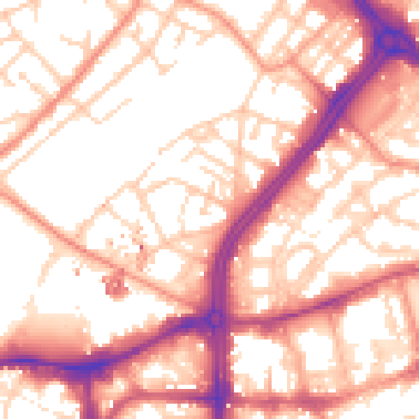
Daytime· 07:00 – 23:00
56.1dB

Night-time· 23:00 – 07:00
45.5dB