1 Valentines Court, Coal Aston, Dronfield, S18 3DH
About 1 Valentines Court
1 Valentines Court is a detached house in Coal Aston, Dronfield, Dronfield (S18 3DH). It has a recorded floor area of 203 m² (around 2185 sq ft). The latest certificate (February 2021) returns a high B (score 87), putting the home a stone's throw from an A rating. The recommended improvements would push it to A (score 93).
Today's modelled estimate of £725,000 is 16% above the 2021 sale price. On a £-per-square-foot basis, the last sale (£286/sq ft) was about 75% above the typical sold price in the postcode. Last sale on file: £625,000 in May 2021. That sale was during the post-pandemic price surge, when transactions cleared materially above pre-2020 trend.
Know exactly what you're buying at 1 Valentines Court
Before you offer, see what the listing won't tell you, the true value, the red flags and the full history.
Valuation
against the asking price
Risks
planning & flood
Sold prices
similar homes nearby
Trends
the local market
Energy performance
Achieving this rating across a home of this size is uncommon — larger homes typically score lower.
EPC Rating
Planning history
1 Valentines Court has no planning applications on record.
The full report still covers planning activity across the surrounding area.
Sales history & valuation
The latest sale landed in the post-pandemic price surge — useful context when reading the figure.
£725,000
Modelled from EPC, postcode comparables.
£625,000
Recorded with HM Land Registry.
Sales timeline
17 May 2021Most recent
£625,000
Median price across the last 5 sales in S18 3DH: £415,000 (2023–2018).
Nearby sales in S18 3DH
Everything we know about 1 Valentines Court, in one report
What it's really worth, what could be wrong, and the planning, sales and area data in full.
- Am I paying too much?
- Is something wrong with it?
- Is the agent's story true?
- Will it hold its value?

Versus other Valentines Court homes
On price per m², 1 Valentines Court stands well clear of the street.
Price per m²
£3,079
Street avg £2,127
Floor Area
203 m²
Street avg 232 m²
CO₂ Emissions
2.5 t/year
Street avg 3.0 t/year
Years Held
5 years
Street avg 5 years
Similar properties nearby
1 Firthwood Road, Coal Aston
S18 3BW
1 Forresters Lane, Coal Aston
S18 3AN
1 Deakon Drive, Coal Aston
S18 3DJ
1 Stone Close, Coal Aston
S18 3AS
1 Ferndale Rise, Coal Aston
S18 3BS
1 Eckington Road, Coal Aston
S18 3AT
1 Ferndale Road, Coal Aston
S18 3BT
1 Firthwood Close, Coal Aston
S18 3DD
The neighbourhood at a glance
Daytime road noise here sits well below conversation level — a quiet pocket of the postcode.
Crime
5/mo
Steady year-on-year across the wider district.
Nearest stop
0.1 km
Ferndale Road Top — bus stop.
Closest school
0.4 km
Northfield Junior School. 15 schools nearby.
Go deeper on the local area
The full report breaks down crime, transport links, schools and air quality in depth.
Road noise across the postcode
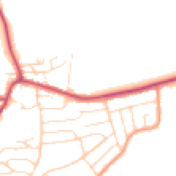
Daytime· 07:00 – 23:00
47.1dB

Night-time· 23:00 – 07:00
38.9dB