159 Hall Road, Handsworth, Sheffield, S13 9AL
About 159 Hall Road
159 Hall Road is a three-bedroom mid-terrace house in Handsworth, Sheffield, Sheffield (S13 9AL). It has a recorded floor area of 63 m² (around 678 sq ft), construction records dating it to before 1900 and council tax band A. The latest certificate (June 2025) shows a D (score 66), on the cusp of jumping into the C band. The recommended improvements would lift it to B (score 82), a 2-band jump.
Held since October 2006 — that's 20 years off the open market, well above the local norm. Across 1999–2006, sale prices on this property compounded at 14.6% per year. Today's modelled estimate of £175,000 sits 59.1% above the 2006 sale of £110,000. On a £-per-square-foot basis, the last sale (£162/sq ft) was about 33.3% above the typical sold price in the postcode. At 63 m² it's 22.2% smaller than the typical home in the postcode (81 m² median across 22 EPCs).
What this property has
Inside
- Bedrooms3
- Bathrooms1
Everything you need to know about 159 Hall Road
The true value, the hidden risks and the full sale history, in one report.
30-day money-back guarantee

The data behind every report


Energy performance
Recommended upgrades on file would lift this property by multiple EPC bands.
EPC Rating
Planning history
159 Hall Road has no planning applications on record.
The full report still covers planning activity across the surrounding area.
Sales history & valuation
Sale price has at least doubled since 1999.
£175,000
Modelled from EPC, postcode comparables and a sale-price growth of 14.6% per year over 7 years.
£110,000
Growth on file: 14.6% per year over 7 years.
Sales timeline
12 October 2006Most recent
£110,000
+89.7%over 4 years3 July 2002
£58,000
+36.5%over 2 years14 October 1999
£42,500
Median price across the last 5 sales in S13 9AL: £155,500 (2025–2022).
Nearby sales in S13 9AL
185 Hall Road, Handsworth, Sheffield, S13 9AL
Sold Aug 2025
£330,000177 Hall Road, Handsworth, Sheffield, S13 9AL
Sold Apr 2024
£210,000151 Hall Road, Handsworth, Sheffield, S13 9AL
Sold Dec 2023
£145,000161 Hall Road, Handsworth, Sheffield, S13 9AL
Sold May 2023
£141,500173 Hall Road, Handsworth, Sheffield, S13 9AL
Sold Dec 2022
£155,500
Versus other Hall Road homes
159 Hall Road outperforms the street on co₂ emissions by a wide margin.
Price per m²
£1,746
Street avg £1,655
Floor Area
63 m²
Street avg 88 m²
Habitable Rooms
5 rooms
Street avg 5 rooms
CO₂ Emissions
2.9 t/year
Street avg 4.6 t/year
Everything you need to know about 159 Hall Road
The true value, the hidden risks and the full sale history, in one report.
30-day money-back guarantee
The data behind every report
Similar properties nearby
1 Handsworth Grange Close
S13 9HA
1 Furnace Lane
S13 9XA
1 Hall Road, Handsworth
S13 9AG
1 Falconer Lane
S13 9ZL
1 Flockton Crescent
S13 9QR
1 Ballifield Way
S13 9HY
1 Ballifield Rise
S13 9HU
1 Hail Mary Drive
S13 9XW
The neighbourhood at a glance
Crime
6/mo
Steady year-on-year across the wider district.
Nearest stop
0.1 km
Handsworth Road/Richmond Park Road — bus stop.
Closest school
0.7 km
St Joseph's Primary School. 20 schools nearby.
Go deeper on the local area
The full report breaks down crime, transport links, schools and air quality in depth.
Road noise across the postcode
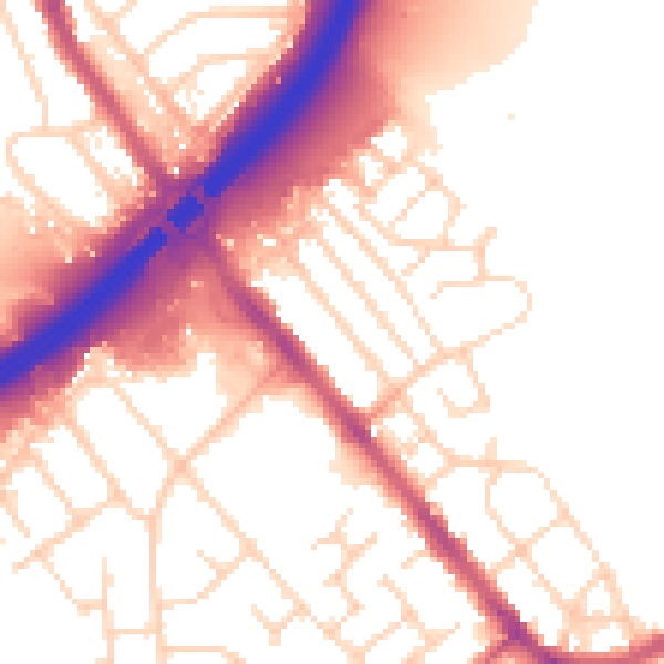
Daytime· 07:00 – 23:00
54.6dB

Night-time· 23:00 – 07:00
45.7dB