8 Abbots Close, Ryde, PO33 4EP
About 8 Abbots Close
8 Abbots Close is a detached house in Ryde (PO33 4EP). It has a recorded floor area of 143 m² (around 1539 sq ft), construction records dating it to 1976-1982 and council tax band F. The latest certificate (October 2024) shows a D (score 60), on the cusp of jumping into the C band. The recommended improvements would push it to C (score 80).
One planning application is currently pending a decision in 2011.
Everything you need to know about 8 Abbots Close
The true value, the hidden risks and the full sale history, in one report.
30-day money-back guarantee

The data behind every report


Energy performance
EPC Rating
Planning history
- Oct 2011
We flagged 1 thing worth checking at 8 Abbots Close
Independent checks surfaced things a buyer would want to understand before offering. The report explains each one in full, with the underlying data and what to ask.
- Larger development activity nearby
30-day money-back guarantee
Sales history & valuation
8 Abbots Close has no Land Registry sales on file, suggesting it has stayed in the same hands since registration began.
£529,000
Modelled from EPC, postcode comparables.
No sales recorded with HM Land Registry
That can mean the property has never traded since the registry began publishing in 1995, was a new build that hasn't been registered yet, or is held in the same hands long-term.
Median price across the last 5 sales in PO33 4EP: £440,000 (2025–2014).
Versus other Abbots Close homes
Habitable Rooms for 8 Abbots Close lags the street by a wide margin.
EPC Rating
60 (D)
Street avg 63 (D)
Floor Area
143 m²
Street avg 131 m²
CO₂ Emissions
5.5 t/year
Street avg 5.2 t/year
Habitable Rooms
4 rooms
Street avg 5 rooms
Everything you need to know about 8 Abbots Close
The true value, the hidden risks and the full sale history, in one report.
30-day money-back guarantee
The data behind every report
Similar properties nearby
1 Binstead Hall, Quarr Road
PO33 4EL
1 Abbots Close
PO33 4EP
1 2 Providence Cottages, Church Road, Havenstreet
PO33 4DG
1 Firestone Glade, Wootton Bridge
PO33 4LH
1 Colemans Wood, Stroud Wood Road
PO33 4BZ
1 Fernhill Cottages, Fernhill, Wootton Bridge
PO33 4QX
1 Glebe Gardens, Wootton Bridge
PO33 4QG
1 Fernside Way, Wootton Bridge
PO33 4QT
The neighbourhood at a glance
Daytime road noise here sits well below conversation level — a quiet pocket of the postcode.
Crime
7/mo
Steady year-on-year across the wider district.
Nearest stop
0.4 km
Newnham Road — bus stop.
Closest school
0.8 km
Binstead Primary School. 5 schools nearby.
Go deeper on the local area
The full report breaks down crime, transport links, schools and air quality in depth.
Road noise across the postcode
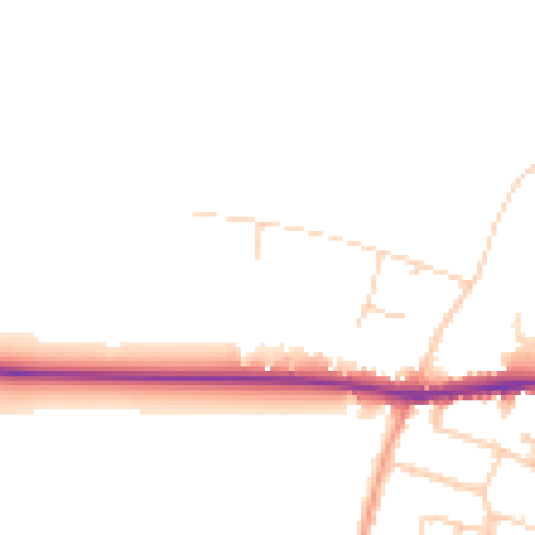
Daytime· 07:00 – 23:00
46.7dB

Night-time· 23:00 – 07:00
40.1dB