Are you a property professional?Get qualified leads from motivated homeowners.
Get started1 Cemetery Road, Abingdon, OX14 1AS
3 sales on record
About 1 Cemetery Road
A plain-English summary derived from public records, EPC certificates, sold prices and local data.
1 Cemetery Road is a four-bedroom semi-detached house in Abingdon (OX14 1AS). It has a recorded floor area of 152 m² (around 1636 sq ft), construction records dating it to 1900-1929 and council tax band E. The latest certificate (March 2018) shows a C (score 75), near the top of the C band. When first surveyed in December 2014 the rating was E, the property has climbed 2 bands since. Between certificates, wall efficiency went from Very Poor to Good, roof efficiency went from Very Poor to Very Good and window efficiency went from Poor to Good. The recommended improvements would push it to B (score 83).
Sale prices here have outpaced England HPI: 15.3% per year against 0% for the wider region. At 152 m² the property is well over the postcode median (80 m² across 7 EPCs), placing it in the larger end of the local stock. Its energy rating outperforms most of the postcode (better than 71% of similar EPCs). Sold August 2021 for £723,250. That sale was during the post-pandemic price surge, when transactions cleared materially above pre-2020 trend. One historical planning record sits against the property in 2015.
What this property has
Pulled from EPC certificates, claim submissions and our property model. Empty categories are hidden — we only show what's known.
Inside
- Bedrooms4
- Bathrooms4
- Open-plan layoutYes
- Dining roomYes
Energy performance
Every EPC certificate filed against this property — current rating, recorded improvements, and where there's headroom to reach a higher band.
Current Certificate(1 of 2)
Mar 2018
EPC Rating
A
B
C
C75
D
E
F
G
Main Heating
Gas
Main Fuel
Gas
Hot Water
Good
Windows
Good
CO2 Emissions
3.8 t/year
Occupancy
Owner Occupied
Planning history
Applications and permits filed against 1 Cemetery Road, Abingdon, OX14 1AS, sourced from the PlanIt planning register.
- Nov 2015ExtensionFullPlanning Permission
Proposed construction of two storey side extension and single storey rear extension. Including for new dormer to side elevation. (As amended by documentation received 13th October submitted by the agent)
Sales history & valuation
Recorded transactions, our model's current estimate, and a quick read on what neighbouring properties have sold for.
Latest sale on 1 Cemetery Road was the highest on Land Registry record across the postcode.
Current estimate
See how we calculated this£786,000
Modelled from EPC, postcode comparables and a sale-price growth of 15.3% per year over 6 years.
Last sold (2021)
£723,250
Growth on file: 15.3% per year over 6 years.
Sales timeline
Versus other Cemetery Road homes
Four headline reads against 7 similar houses on this street, drawn from the latest EPC and Land Registry data.
EPC Rating for 1 Cemetery Road runs comfortably ahead of the street norm.
Price per m²
£4,758
Street avg £4,635
Floor Area
152 m²
Street avg 93 m²
Habitable Rooms
8 rooms
Similar properties nearby
A handful of close matches in the same postcode area, ranked by likeness on bedrooms, type and floor area.
The neighbourhood at a glance
A condensed read of the local area. Each tile links through to the full breakdown on the Abingdon district page.
Crime
6/mo
Steady year-on-year across the wider district.
Nearest stop
0.3 km
Colwell Drive — bus stop.
Road noise across the postcode
Modelled day and night-time noise levels around OX14 1AS from Defra's strategic mapping. The pin marks this postcode's centroid.
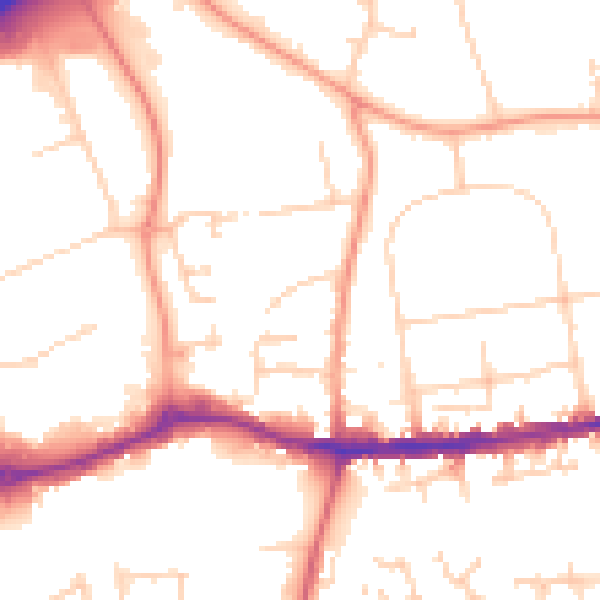
Daytime· 07:00 – 23:00
52.4dB

Everything within walking distance
Schools, transport stops and scenic spots near this property — 45 points of interest in total.
Beautiful places to visit nearby
Curated scenic spots within reach of this postcode, served by Beautifulplaces.ai. Photography and tagging come from their open dataset.
Common questions
The questions buyers, sellers and homeowners most often ask about 1 Cemetery Road, Abingdon, OX14 1AS. Each answer is also embedded as structured data for search engines.