15 Kenville Road, Kennington, Oxford, OX1 5PJ
About 15 Kenville Road
15 Kenville Road is a two-bedroom detached house in Kennington, Oxford, Oxford (OX1 5PJ). It has a recorded floor area of 100 m² (around 1076 sq ft), construction records dating it to 1930-1949 and council tax band D. Tenure is freehold. The latest certificate (December 2023) shows an E (score 47), well below the UK norm with real room to improve. The recommended improvements would push it to D (score 66). Other recorded features include a conservatory.
At 100 m² the property is well over the postcode median (58 m² across 11 EPCs), placing it in the larger end of the local stock. On energy efficiency it sits in the bottom 10% of properties in this postcode — significant headroom for improvement. Today's modelled estimate of £461,000 is 13.8% above the 2024 sale price. On a £-per-square-foot basis, the last sale (£376/sq ft) was about 143% above the typical sold price in the postcode. Last sale on file: £405,000 in May 2024.
What this property has
Inside
- Bedrooms2
- Bathrooms1
- ConservatoryYes
Outside
- Private gardenYes
- GarageYes
Building
- TenureFreehold
- Heating systemGas
Everything you need to know about 15 Kenville Road
The true value, the hidden risks and the full sale history, in one report.
30-day money-back guarantee

The data behind every report


Energy performance
15 Kenville Road sits at the bottom of the postcode for energy efficiency — meaningful headroom to improve.
EPC Rating
Planning history
15 Kenville Road has no planning applications on record.
Notable planning nearby
5applications of note in the surrounding area
We flagged 1 thing worth checking at 15 Kenville Road
Independent checks surfaced things a buyer would want to understand before offering. The report explains each one in full, with the underlying data and what to ask.
- Larger development activity nearby
30-day money-back guarantee
Sales history & valuation
Latest sale on 15 Kenville Road was the highest on Land Registry record across the postcode.
£461,000
Modelled from EPC, postcode comparables.
£405,000
Recorded with HM Land Registry.
Sales timeline
30 May 2024Most recent
£405,000
Median price across the last 5 sales in OX1 5PJ: £225,000 (2019–2005).
Nearby sales in OX1 5PJ
5 Kenville Road, Kennington, Oxford, OX1 5PJ
Sold Oct 2019
£383,000Hundar Court, Flat 5, Kenville Road, Kennington, Oxford, OX1 5PJ
Sold Aug 2018
£225,00013 Kenville Road, Kennington, Oxford, OX1 5PJ
Sold Nov 2016
£345,000Hundar Court, Flat 1, Kenville Road, Kennington, Oxford, OX1 5PJ
Sold May 2007
£90,000Hundar Court, Flat 4, Kenville Road, Kennington, Oxford, OX1 5PJ
Sold Dec 2005
£172,500
Versus other Kenville Road homes
15 Kenville Road is notably below the street on years held.
Price per m²
£4,050
Street avg £4,191
Floor Area
100 m²
Street avg 103 m²
Habitable Rooms
4 rooms
Street avg 5 rooms
CO₂ Emissions
6.5 t/year
Street avg 3.9 t/year
Everything you need to know about 15 Kenville Road
The true value, the hidden risks and the full sale history, in one report.
30-day money-back guarantee
The data behind every report
Similar properties nearby
1 Otters Reach, Kennington
OX1 5QL
1 Links Road, Kennington
OX1 5RX
1 Beaumont Court, The Avenue
OX1 5AL
1 Fairways, Kennington
OX1 5RQ
1 Playfield Road, Kennington
OX1 5RS
1 Bagley Close, Kennington
OX1 5LS
1 Bagley Wood Road, Kennington
OX1 5PL
1 Grundy Crescent, Kennington
OX1 5PS
The neighbourhood at a glance
Reported crime in the wider district is trending notably upward year-on-year.
Crime
6/mo
Rising year-on-year across the wider district.
Nearest stop
0.1 km
Kenville Road — bus stop.
Closest school
0.9 km
St Swithun's CofE Primary School. 14 schools nearby.
Go deeper on the local area
The full report breaks down crime, transport links, schools and air quality in depth.
Road noise across the postcode
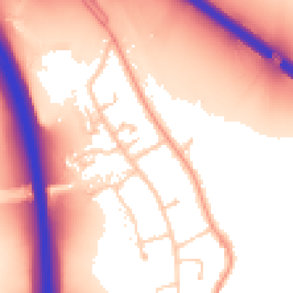
Daytime· 07:00 – 23:00
57.7dB

Night-time· 23:00 – 07:00
51.0dB