23c 23d, Dennington Park Road, Camden, London, NW6 1BB
About 23c 23d
23c 23d is a mid-terrace house in Camden, London, London (NW6 1BB). It has a recorded floor area of 69 m² (around 743 sq ft) and construction records dating it to 1900-1929. The latest certificate (November 2022) shows a C (score 77), near the top of the C band. The rating has held steady at C across 7 certificates since November 2008. Between certificates, lighting went from Very Poor to Very Good. The recommended improvements would push it to B (score 83).
At 69 m² it's 15% larger than the typical home in the postcode (60 m² median across 82 EPCs).
Everything you need to know about 23c 23d
The true value, the hidden risks and the full sale history, in one report.
30-day money-back guarantee

The data behind every report


Energy performance
EPC Rating
Property Improvements
Changes detected from historical EPC data
Heating controls changed
Single glazing replaced with double or better glazing
More low energy lighting installed
More low energy lighting installed
Heating controls upgraded for better temperature management
Single glazing replaced with double or better glazing
Heating controls changed
More low energy lighting installed
Single glazing replaced with double or better glazing
Heating controls upgraded for better temperature management
Planning history
23c 23d has no planning applications on record.
Notable planning nearby
1applications of note in the surrounding area
Sales history & valuation
23c 23d has no Land Registry sales on file, suggesting it has stayed in the same hands since registration began.
£632,000
Modelled from EPC, postcode comparables.
No sales recorded with HM Land Registry
That can mean the property has never traded since the registry began publishing in 1995, was a new build that hasn't been registered yet, or is held in the same hands long-term.
Median price across the last 5 sales in NW6 1BB: £525,000 (2025–2023).
Nearby sales in NW6 1BB
21a, Dennington Park Road, Camden, London, NW6 1BB
Sold Aug 2025
£640,000Flat 4, 9 Dennington Park Road, London, NW6 1BB
Sold Mar 2025
£415,000Flat 3, 17 Dennington Park Road, Camden, London, NW6 1BB
Sold Jan 2025
£355,00023d, Dennington Park Road, London, NW6 1BB
Sold Jul 2024
£525,00019b, Dennington Park Road, Camden, London, NW6 1BB
Sold Sept 2023
£790,000
Versus other Dennington Park Road homes
23c 23d outperforms the street on epc rating by a wide margin.
EPC Rating
77 (C)
Street avg 68 (D)
Floor Area
69 m²
Street avg 52 m²
CO₂ Emissions
1.6 t/year
Street avg 2.1 t/year
Habitable Rooms
3 rooms
Street avg 2 rooms
Everything you need to know about 23c 23d
The true value, the hidden risks and the full sale history, in one report.
30-day money-back guarantee
The data behind every report
Similar properties nearby
1 Carlton Mews, West End Lane, Camden
NW6 1RL
1 Holly Mansions, Fortune Green Road, Camden
NW6 1UB
1 Oliver Mansions, Gondar Gardens
NW6 1HF
1 Eden Mansions, Gondar Gardens, Camden
NW6 1HE
1 Inglewood Road, Camden
NW6 1QT
1 Gondar Cottage, Gondar Gardens, Camden
NW6 1QG
1 Glastonbury Street, Camden
NW6 1QJ
1 Inglewood Mews, Inglewood Road
NW6 1QY
The neighbourhood at a glance
Rail-style transport is unusually close for this postcode.
Crime
8/mo
Rising year-on-year across the wider district.
Nearest stop
0.2 km
Dennington Park Road — bus stop.
Closest school
0.3 km
Emmanuel Church of England Primary School. 65 schools nearby.
Go deeper on the local area
The full report breaks down crime, transport links, schools and air quality in depth.
Road noise across the postcode
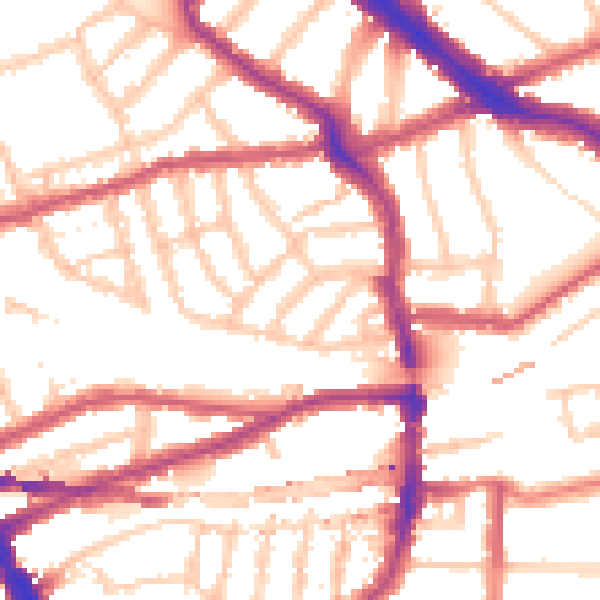
Daytime· 07:00 – 23:00
53.9dB

Night-time· 23:00 – 07:00
43.2dB