Are you a property professional?Get qualified leads from motivated homeowners.
Get started5 Yarrow Road, Dereham, NR20 3BH
About 5 Yarrow Road
A plain-English summary derived from public records, EPC certificates, sold prices and local data.
5 Yarrow Road is a three-bedroom detached house in Dereham (NR20 3BH). It has a recorded floor area of 121 m² (around 1302 sq ft), construction records dating it to 1967-1975 and council tax band C. The latest certificate (April 2014) shows a C (score 71). The recommended improvements would push it to B (score 84). The latest certificate is from April 2014, so improvements made since then won't be reflected.
Untraded for 19 years, with the last transfer in August 2007. That sale landed at the peak of the pre-credit-crunch market, which is a useful reference point when interpreting the price. Today's modelled estimate of £299,000 is 49.9% above the 2007 sale price. On a £-per-square-foot basis, the last sale (£153/sq ft) was about 70.9% above the typical sold price in the postcode.
What this property has
Pulled from EPC certificates, claim submissions and our property model. Empty categories are hidden — we only show what's known.
Inside
- Bedrooms3
Energy performance
Every EPC certificate filed against this property — current rating, recorded improvements, and where there's headroom to reach a higher band.
5 Yarrow Road's EPC is over a decade old — improvements since won't be reflected.
EPC Expired
This certificate is over 10 years old and is no longer valid.Expired 28 Apr 2024
Sales history & valuation
Recorded transactions, our model's current estimate, and a quick read on what neighbouring properties have sold for.
The latest sale landed at the peak of the pre-credit-crunch market — a high-water reference point.
Current estimate
See how we calculated this£299,000
Modelled from EPC, postcode comparables.
Last sold (2007)
£199,500
Recorded with HM Land Registry.
Sales timeline
Full property reportLaunch offer · 33% off
The complete analysis of 5 Yarrow Road, Dereham, NR20 3BH
Everything we know about this property, compiled into one in-depth, downloadable report.
Detailed AI analysis
Similar properties nearby
A handful of close matches in the same postcode area, ranked by likeness on bedrooms, type and floor area.
The neighbourhood at a glance
A condensed read of the local area. Each tile links through to the full breakdown on the Dereham district page.
Daytime road noise here sits well below conversation level — a quiet pocket of the postcode.
Crime
1/mo
Steady year-on-year across the wider district.
Nearest stop
1.3 km
Road noise across the postcode
Modelled day and night-time noise levels around NR20 3BH from Defra's strategic mapping. The pin marks this postcode's centroid.
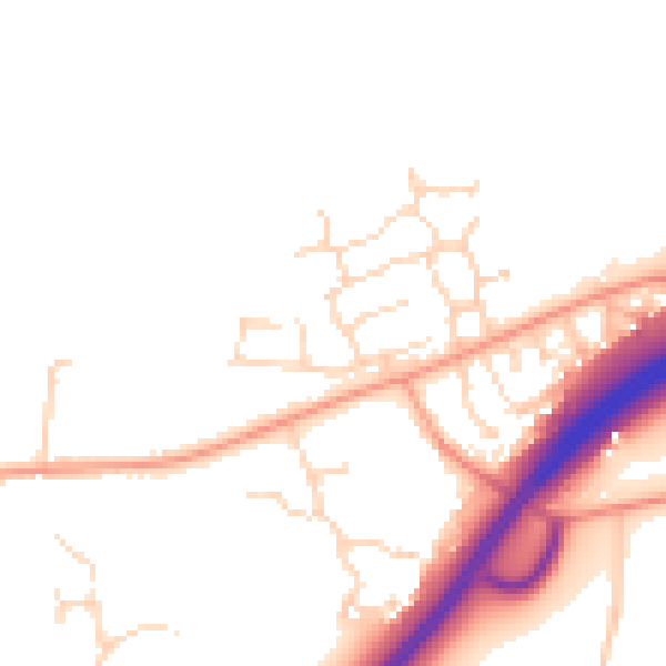
Daytime· 07:00 – 23:00
48.9dB

Everything within walking distance
Schools, transport stops and scenic spots near this property — 10 points of interest in total.
Common questions
The questions buyers, sellers and homeowners most often ask about 5 Yarrow Road, Dereham, NR20 3BH. Each answer is also embedded as structured data for search engines.