34 36, Flat 7, High Street, Kettering, NN16 8SU
About 34 36
34 36 is a semi-detached house in Kettering (NN16 8SU). It has a recorded floor area of 33 m² (around 355 sq ft) and construction records dating it to before 1900. The latest certificate (September 2022) shows an E (score 54), well below the UK norm with real room to improve. When first surveyed in October 2012 the rating was F, the property has climbed 1 band since. Between certificates, wall efficiency went from Very Poor to Poor and roof efficiency went from Very Poor to Very Good; while hot-water efficiency dropped from Average to Poor and main heating dropped from Poor to Very Poor. The recommended improvements would lift it to C (score 75), a 2-band jump. Main heating runs on electricity. At 33 m² this is the 3rd smallest of 7 units on EPC record in 34 36, where floor areas span 24–68 m². The building's EPC ratings span E to D, with this unit at the bottom.
At 33 m² it's 16.5% smaller than the typical home in the postcode (40 m² median across 6 EPCs).
Know exactly what you're buying at 34 36
Before you offer, see what the listing won't tell you, the true value, the red flags and the full history.
Already flagged here
Valuation
against the asking price
Risks
planning & flood
Sold prices
similar homes nearby
Trends
the local market
Energy performance
Recommended upgrades on file would lift this property by multiple EPC bands.
EPC Rating
Property Improvements
Changes detected from historical EPC data
Hot water efficiency decreased
More low energy lighting installed
Wall insulation improved
Loft insulation installed or upgraded to 250mm+
Planning history
34 36 has no planning applications on record.
Notable planning nearby
18applications of note in the surrounding area
We flagged 2 things worth checking at 34 36
Independent checks surfaced things a buyer would want to understand before offering. The report explains each one in full, with the underlying data and what to ask.
- Signs of HMO activity in the area
- Larger development activity nearby
30-day money-back guarantee
Sales history & valuation
34 36 has no Land Registry sales on file, suggesting it has stayed in the same hands since registration began.
£139,000
Modelled from EPC, postcode comparables.
No sales recorded with HM Land Registry
That can mean the property has never traded since the registry began publishing in 1995, was a new build that hasn't been registered yet, or is held in the same hands long-term.
Median price across the last 1 sales in NN16 8SU: £2,115,200 (2022–2022).
Nearby sales in NN16 8SU
Everything we know about 34 36, in one report
What it's really worth, what could be wrong, and the planning, sales and area data in full.
What we flagged
- Signs of HMO activity in the area
- Larger development activity nearby

Versus other High Street homes
EPC Rating
54 (E)
Street avg 47 (E)
Floor Area
33 m²
Street avg 42 m²
CO₂ Emissions
2.9 t/year
Street avg 3.7 t/year
Habitable Rooms
2 rooms
Street avg 2 rooms
Similar properties nearby
15 17, Flat 2, High Street
NN16 8ST
22 24, Flat 1b, High Street
NN16 8ST
34 36, Flat 2, High Street
NN16 8SU
15 17, Flat 5, High Street
NN16 8ST
26a, Flat 2, Rockingham Road
NN16 8JS
27a, Flat 1, High Street
NN16 8ST
26a, Flat 3, Rockingham Road
NN16 8JS
34 36, Flat 3, High Street
NN16 8SU
The neighbourhood at a glance
Rail-style transport is unusually close for this postcode.
Crime
4/mo
Steady year-on-year across the wider district.
Nearest stop
0.1 km
The Royal Hotel — bus stop.
Closest school
0.7 km
St Thomas More Catholic Primary School. 19 schools nearby.
Go deeper on the local area
The full report breaks down crime, transport links, schools and air quality in depth.
Road noise across the postcode
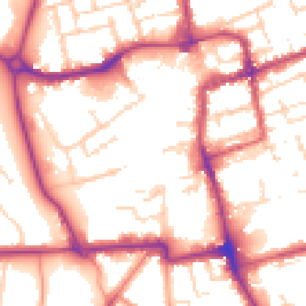
Daytime· 07:00 – 23:00
54.9dB

Night-time· 23:00 – 07:00
46.2dB