1 Almond Grove, Farndon, Newark, NG24 3TD
About 1 Almond Grove
1 Almond Grove is a five-bedroom semi-detached house in Farndon, Newark, Newark (NG24 3TD). It has a recorded floor area of 127 m² (around 1367 sq ft), construction records dating it to 1967-1975 and council tax band A. Tenure is freehold. The latest certificate (October 2024) shows a C (score 74). The rating has held steady at C across 2 certificates since June 2010. Between certificates, lighting went from Very Poor to Very Good; while wall efficiency dropped from Good to Average and roof efficiency dropped from Very Good to Good. The recommended improvements would push it to B (score 83). Other recorded features include a conservatory. Records show the property has been extended at some point in its history.
At 127 m² the property is well over the postcode median (78 m² across 23 EPCs), placing it in the larger end of the local stock. 5 bedrooms is on the larger side for this postcode, where 3 is the typical count. It changed hands recently, sold May 2025 for £255,000. One planning record on file: an extension approved in 2005. Past consents include an extension, meaningful when judging how the property has evolved. On a £-per-square-foot basis, the last sale (£187/sq ft) was about 24.9% above the typical sold price in the postcode.
What this property has
Inside
- Bedrooms5
- Bathrooms2
- CloakroomYes
- EnsuiteYes
- ConservatoryYes
Outside
- Private gardenYes
- DrivewayYes
Building
- TenureFreehold
- Previously extendedYes
- RefurbishedYes
Everything you need to know about 1 Almond Grove
The true value, the hidden risks and the full sale history, in one report.
Pick your report · from £14.99
One time fee only - money back guarantee

The data behind every report







Energy performance
EPC Rating
Certificate validity
Valid until 30 October 2034
Property Improvements
Changes detected from historical EPC data
Heating controls upgraded for better temperature management
More low energy lighting installed

Get a survey for this property
Level 3 Building Survey
Because the property has been extended more than once, we believe a Level 3 building survey should be considered.
From £885 · Includes VAT
Planning history
1 Almond Grove has an approved extension on the planning record.
1 application on record at 1 Almond Grove, Farndon, Newark, NG24 3TD
- Mar 2005ExtensionFullOutcome in report
Two storey extension to form kitchen/diner and fourth bedroom
- Documents
- 1 doc on file
- Reference
- 05/00085/FUL
Unlock 1 Almond Grove, Farndon, Newark, NG24 3TD's full planning history
You're seeing the shape of it. The report has the substance.
- Every decision — granted, refused or withdrawn (1 on record)
- All 1 application on this property in full, plus 6 notable nearby
- The 1 documents, officer reports & conditions
- What the pattern means for extending or converting here
One time fee only - money back guarantee
Sales history & valuation
Latest sale on 1 Almond Grove was the highest on Land Registry record across the postcode.
£279,000
Modelled from EPC, postcode comparables.
£255,000
Recorded with HM Land Registry.
Sales timeline
19 May 2025Most recent
£255,000
Median price across the last 5 sales in NG24 3TD: £197,500 (2022–2016).
Nearby sales in NG24 3TD
8 Almond Grove, Farndon, Newark, NG24 3TD
Sold Jun 2022
£220,0006 Almond Grove, Farndon, Newark, NG24 3TD
Sold Jun 2022
£247,00010 Almond Grove, Farndon, Newark, NG24 3TD
Sold Sept 2021
£197,50013 Almond Grove, Farndon, Newark, NG24 3TD
Sold Apr 2020
£183,50012 Almond Grove, Farndon, Newark, NG24 3TD
Sold Dec 2016
£151,000
Versus other Almond Grove homes
On years held, 1 Almond Grove runs well behind the street norm.
Price per m²
£2,008
Street avg £1,773
Floor Area
127 m²
Street avg 73 m²
Habitable Rooms
8 rooms
Street avg 5 rooms
CO₂ Emissions
3.3 t/year
Street avg 2.6 t/year
Everything you need to know about 1 Almond Grove
The true value, the hidden risks and the full sale history, in one report.
Pick your report · from £14.99
One time fee only - money back guarantee
The data behind every report
Similar properties nearby
1 Barkstone Close, Balderton
NG24 3HT
1 Anderson Close, Balderton
NG24 3GD
1 Acacia Road, Balderton
NG24 3AE
1 Apple Avenue, Fernwood
NG24 3US
1 Alder Close, Balderton
NG24 3AY
1 Acorn Close, Balderton
NG24 3AX
1 Brooke Close, Balderton
NG24 3QN
1 Albert Avenue, Balderton
NG24 3HE
The neighbourhood at a glance
Daytime road noise here sits well below conversation level — a quiet pocket of the postcode.
Crime
467/mo
Falling year-on-year across the wider district.
Nearest stop
0.0 km
Oak Avenue — bus stop.
Closest school
0.4 km
St Peter's Crosskeys CofE Academy. 5 schools nearby.
Go deeper on the local area
A Local Area report breaks down crime, transport links, schools and air quality in depth.
Road noise across the postcode
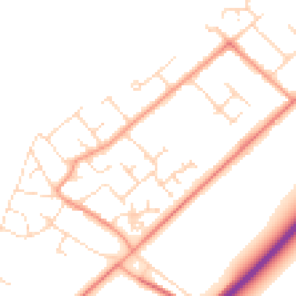
Daytime· 07:00 – 23:00
49.1dB

Night-time· 23:00 – 07:00
39.1dB