18 Friar Street, Long Eaton, Nottingham, NG10 1BZ
About 18 Friar Street
18 Friar Street is a two-bedroom property in Long Eaton, Nottingham, Nottingham (NG10 1BZ). It has council tax band A. Period features are noted in the property record.
Untraded for 26 years, with the last transfer in June 2000. Only one transfer is on record with HM Land Registry, suggesting it has stayed in the same hands for a long time.
Know exactly what you're buying at 18 Friar Street
Before you offer, see what the listing won't tell you, the true value, the red flags and the full history.
Already flagged here
Valuation
against the asking price
Risks
planning & flood
Sold prices
similar homes nearby
Trends
the local market
What this property has
Inside
- Bedrooms2
- Dining roomYes
- StudyYes
Outside
- Private gardenRear
- ParkingOff road
Building
- Heating systemGas
- Period featuresYes
- RefurbishedYes
Energy performance
No EPC on record
This property doesn't have an Energy Performance Certificate yet. An EPC is required to sell or let — and unlocks our automated valuation.
Planning history
18 Friar Street has no planning applications on record.
Notable planning nearby
18applications of note in the surrounding area
We flagged 2 things worth checking at 18 Friar Street
Independent checks surfaced things a buyer would want to understand before offering. The report explains each one in full, with the underlying data and what to ask.
- Signs of HMO activity in the area
- Larger development activity nearby
30-day money-back guarantee
Sales history & valuation
£30,000
Recorded with HM Land Registry.
Sales timeline
22 June 2000Most recent
£30,000
Median price across the last 5 sales in NG10 1BZ: £160,000 (2025–2022).
Nearby sales in NG10 1BZ
11 Friar Street, Long Eaton, Nottingham, NG10 1BZ
Sold Oct 2025
£168,00039 Friar Street, Long Eaton, Nottingham, NG10 1BZ
Sold Jun 2024
£147,00024 Friar Street, Long Eaton, Nottingham, NG10 1BZ
Sold Mar 2024
£160,00015 Friar Street, Long Eaton, Nottingham, NG10 1BZ
Sold Mar 2023
£165,00017 Friar Street, Long Eaton, Nottingham, NG10 1BZ
Sold Nov 2022
£125,000
Everything we know about 18 Friar Street, in one report
What it's really worth, what could be wrong, and the planning, sales and area data in full.
What we flagged
- Signs of HMO activity in the area
- Larger development activity nearby

Similar properties nearby
1 Brook Close, Long Eaton
NG10 1QA
1 Collingwood Road, Long Eaton
NG10 1DR
1 Acton Road, Long Eaton
NG10 1FR
1 Belvoir Close, Long Eaton
NG10 1NW
1 Dale Avenue, Long Eaton
NG10 1NP
1 Farm Close, Long Eaton
NG10 1PL
1 Friar Street, Long Eaton
NG10 1BZ
1 Abbott Street, Long Eaton
NG10 1DF
The neighbourhood at a glance
Daytime road noise here sits well below conversation level — a quiet pocket of the postcode.
Crime
6/mo
Steady year-on-year across the wider district.
Nearest stop
0.1 km
Nelson Street — bus stop.
Closest school
0.1 km
Brooklands Primary School. 16 schools nearby.
Go deeper on the local area
The full report breaks down crime, transport links, schools and air quality in depth.
Road noise across the postcode
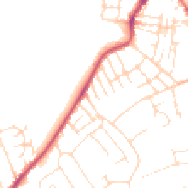
Daytime· 07:00 – 23:00
48.4dB

Night-time· 23:00 – 07:00
38.7dB