Flat 3, 10 Broad Street, Nottingham, NG1 3AL
About Flat 3
Flat 3 is a mid-terrace house in Nottingham (NG1 3AL). It has a recorded floor area of 42 m² (around 452 sq ft), construction records dating it to 1991-1995 and council tax band A. The latest certificate (May 2020) returns a B (score 81), comfortably above the UK average. When first surveyed in November 2008 the rating was D, the property has climbed 2 bands since. Between certificates, wall efficiency went from Very Poor to Good, lighting went from Very Poor to Very Good and main heating went from Poor to Average. Main heating runs on electricity. At 42 m² this is the 29th smallest of 34 units on EPC record in the building, where floor areas span 24–48 m². The building's EPC ratings span E to B, with this unit at the top.
Its energy rating outperforms most of the postcode (better than 78% of similar EPCs).
Everything you need to know about Flat 3
The true value, the hidden risks and the full sale history, in one report.
Pick your report · every report is £14.99
One time fee only - money back guarantee

The data behind every report


Energy performance
For a compact home of this size, this rating sits in the top tier locally.
EPC Rating
Property Improvements
Changes detected from historical EPC data
Hot water efficiency decreased
External or internal wall insulation added
More low energy lighting installed
Hot water efficiency improved
Get a survey for this property
Level 3 Building Survey
Because the property has no mains gas supply and has solid (non-cavity) walls, we believe a Level 3 building survey should be considered.
From £820 · Includes VAT
Planning history
Flat 3 has no planning applications on record.
But the area is active
12 notable applications nearby — larger schemes and conversions that could reshape the street. The report maps them all.
Sales history & valuation
Flat 3 has no Land Registry sales on file, suggesting it has stayed in the same hands since registration began.
£114,000
Modelled from EPC, postcode comparables.
No sales recorded with HM Land Registry
That can mean the property has never traded since the registry began publishing in 1995, was a new build that hasn't been registered yet, or is held in the same hands long-term.
Versus other Broad Street homes
EPC Rating for Flat 3 runs comfortably ahead of the street norm.
EPC Rating
81 (B)
Street avg 75 (C)
Floor Area
42 m²
Street avg 44 m²
CO₂ Emissions
1.7 t/year
Street avg 2.0 t/year
Habitable Rooms
2 rooms
Street avg 2 rooms
Everything you need to know about Flat 3
The true value, the hidden risks and the full sale history, in one report.
Pick your report · every report is £14.99
One time fee only - money back guarantee
The data behind every report
Similar properties nearby
12a, Flat 17, Lower Parliament Street
NG1 3DA
12a, Flat 12, Lower Parliament Street
NG1 3DA
20 22, Flat 6, Broad Street
NG1 3AL
20 22, Flat 5, Broad Street
NG1 3AL
12a, Flat 10, Lower Parliament Street
NG1 3DA
12a, Flat 11, Lower Parliament Street
NG1 3DA
12a, Flat 15, Lower Parliament Street
NG1 3DA
12a, Flat 16, Lower Parliament Street
NG1 3DA
The neighbourhood at a glance
Rail-style transport is unusually close for this postcode.
Crime
39/mo
Rising year-on-year across the wider district.
Nearest stop
0.1 km
George Street — bus stop.
Closest school
0.1 km
Nottingham College. 43 schools nearby.
Go deeper on the local area
A Local Area report breaks down crime, transport links, schools and air quality in depth.
Road noise across the postcode
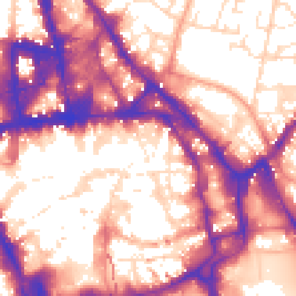
Daytime· 07:00 – 23:00
59.7dB

Night-time· 23:00 – 07:00
50.5dB