16 Brinkburn Avenue, Newcastle Upon Tyne, NE3 3HU
About 16 Brinkburn Avenue
16 Brinkburn Avenue is a semi-detached house in Newcastle Upon Tyne (NE3 3HU). It has a recorded floor area of 81 m² (around 872 sq ft), construction records dating it to 1930-1949 and council tax band C. The latest certificate (December 2020) shows a D (score 64), on the cusp of jumping into the C band. The recommended improvements would push it to C (score 79).
On a £-per-square-foot basis, the last sale (£272/sq ft) was about 27.6% above the typical sold price in the postcode. At 81 m² it's 18.6% smaller than the typical home in the postcode (100 m² median across 10 EPCs). Sold September 2021 for £237,500. That sale was during the post-pandemic price surge, when transactions cleared materially above pre-2020 trend.
Everything you need to know about 16 Brinkburn Avenue
The true value, the hidden risks and the full sale history, in one report.
30-day money-back guarantee

The data behind every report


Energy performance
EPC Rating
Planning history
16 Brinkburn Avenue has no planning applications on record.
Notable planning nearby
1applications of note in the surrounding area
Sales history & valuation
The latest sale landed in the post-pandemic price surge — useful context when reading the figure.
£248,000
Modelled from EPC, postcode comparables.
£237,500
Recorded with HM Land Registry.
Sales timeline
29 September 2021Most recent
£237,500
Median price across the last 5 sales in NE3 3HU: £312,000 (2024–2021).
Nearby sales in NE3 3HU
19 Brinkburn Avenue, Newcastle Upon Tyne, NE3 3HU
Sold Apr 2024
£312,0001 Brinkburn Avenue, Newcastle Upon Tyne, NE3 3HU
Sold Dec 2023
£285,0008 Brinkburn Avenue, Newcastle Upon Tyne, NE3 3HU
Sold Aug 2023
£270,00020 Brinkburn Avenue, Newcastle Upon Tyne, NE3 3HU
Sold Nov 2022
£350,00014 Brinkburn Avenue, Newcastle Upon Tyne, NE3 3HU
Sold Sept 2021
£318,000
Versus other Brinkburn Avenue homes
Floor Area for 16 Brinkburn Avenue lags the street by a wide margin.
Price per m²
£2,932
Street avg £2,800
Floor Area
81 m²
Street avg 106 m²
Habitable Rooms
5 rooms
Street avg 5 rooms
CO₂ Emissions
4.0 t/year
Street avg 5.1 t/year
Everything you need to know about 16 Brinkburn Avenue
The true value, the hidden risks and the full sale history, in one report.
30-day money-back guarantee
The data behind every report
Similar properties nearby
The neighbourhood at a glance
Rail-style transport is unusually close for this postcode.
Crime
6/mo
Steady year-on-year across the wider district.
Nearest stop
0.2 km
Wansbeck Road (Tyne and Wear Metro Station) — subway entrance.
Closest school
0.2 km
Regent Farm First School. 24 schools nearby.
Go deeper on the local area
The full report breaks down crime, transport links, schools and air quality in depth.
Road noise across the postcode
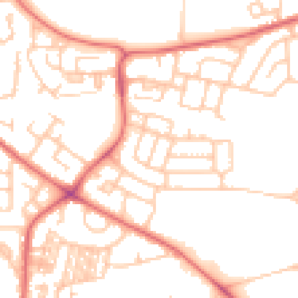
Daytime· 07:00 – 23:00
50.9dB

Night-time· 23:00 – 07:00
38.9dB